
This article concerns the BNSF rail line on the north shore of the various Columbia Lakes as far east as Roosevelt, Washington. I know. I know. Why, you ask, don't I refer to the Columbia River? Well, the Columbia River in the United States and portions of British Columbia no longer exists.
Eleven dams were built on the Columbia River in the United States. (See the end of this article for a list of all 11.) Six were constructed by the federal government -- designed by technocrats, funded by dollars produced like doves out of a magician's sleeve.
Four were constructed by county agencies which, unlike the federal government, cannot create money out of thin air. Municipal bonds were sold to the public to finance construction.
One dam was constructed by a private utility, which raised construction funds by selling corporate bonds.
The difference between municipal and corporate bonds? The interest generated by municipal bonds is tax free. All levels of government always have an edge.
The eleven dams all impound reservoirs -- giant lakes that fill the canyon of the Columbia River from side to side. Thus, the Columbia as it existed for centuries, as salmon swam upriver every season to spawn, as Native Americans fished the blue waters for sustenance, as Lewis and Clark navigated the same waters on the way to the Pacific Ocean -- that river (rapids, falls, white water, motionless pools) has disappeared as surely as pay telephones and can openers, buried beneath the shroud of progress.
The River Before the Dams
Before construction of the dams, the Columbia River was wild and untamed, fierce, life-threatening. Today one sees broad placid water stretching from canyon wall to canyon wall. Yesterday, one saw churning white rapids, protruding boulders as large as whales and majestic waterfalls. Your author never saw the river in its natural state, but old photographs (a few of which are reproduced below) look like another planet, another galaxy.
When Lewis and Clark first encountered the river in October 1805, they rejoiced, expecting a simple float --similar to the Missouri River -- downstream to the Pacific Ocean. Instead, they discovered unrelenting rapids and attacking fleas. The rapids were gigantic, much larger than any encountered previously. Hot dry air from desert-like Eastern Washington (or what would become Washington) met with cool humid air off the Pacific, creating tremendous thermal gusts, strong enough to blow over wagons. No trees grew along the river. Clark reported that native people in one village dried fish and cacti to burn in the winter.
As the expedition continued downriver, trees began to appear, short and gnarled at first, struggling for survival in the arid climate. But within a few miles, the trees grew larger, then larger still, and soon the party found itself in a temperate rain forest, filled with enormous firs, pines and cedars. This more humid territory was home to millions of fleas. The men could obtain relief only by stripping and submerging themselves in the cold river water.
But the greatest obstacle to exploration proved to be the river itself. The various narrow stretches of white water were unexpected and quite spectacular.
One of the first to be encountered, the Short Narrows, caused Clark to write in his journal:
"I deturmined to pass through this place notwithstanding the horrid appearance of this agitated gut Swelling, boiling & whorling in every direction (which from the top of the rock did not appear as bad as when I was in it[)]."
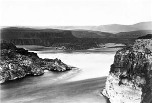
 |
| Short Narrows of the Columbia. |
Later explorers had much the same reaction to the river's untamed ferocity. An expedition under the command of the U.S. Navy's Charles Wilkes encountered The Dalles [rhymes with owls] of the Columbia while traveling upriver in July 1841. Wilkes wrote:
"The Dalles of the Columbia is one of the most remarkable places upon the Columbia. The river is here compressed into a narrow channel, three hundred feet wide, and half a mile long; the walls are perpendicular, flat on the top, and composed of basalt.... The tremendous roar arising from the rushing of the river through this outlet, with the many whirlpools and eddies which it causes, may be more readily imagined than described."
 |
| The Dalles of the Columbia. |
One of the most spectacular locations on the river was Celilo Falls, about 13 miles upstream from today's town of The Dalles, Oregon. Water through the falls was fierce, and Native Americas for centuries gathered along the shore to spear fish. Nearby were two ancient villages -- Wyam, on the Oregon side, S'kin on the other (Washington).
On October 23, 1805, Clark made the following entry in his journal:
"... a fine morning, I with the greater part of the men Crossed in the Canoes to opposit Side above the falls and hauled them across the portage of 457 yards which is on the Lard. Side and certainly the best side to pass the canoes I then decended through a narrow chanel of about 150 yards wide forming a kind of half circle in it course of a mile to a pitch of 8 feet in which the chanel is divided by 2 large rocks at this place we were obliged to let the Canoes down by Strong ropes of Elk Skin which we had for the purpose, one Canoe in passing this place got loose by the Cords breaking, and was cought by the Indians below. I accomplished this necessary business and landed Safe with all the Canoes at our Camp below the falls by 3 oClock P. M. ..."
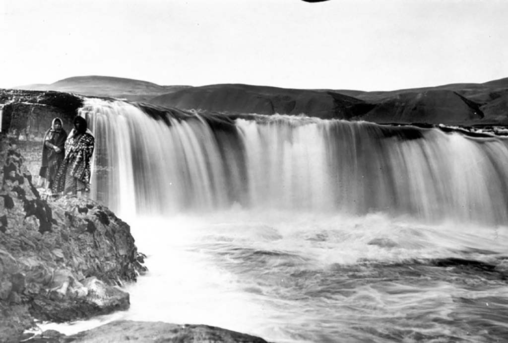 |
Celilo Falls. |
The Cascades of the Columbia were another obstacle. Clark described them as a "Great Shute," extending about one half mile. The river was 150 yards wide and dropped about twenty feet over both large and small rocks, with "water passing with great velocity forming & boiling in a most horriable manner." The raging water then continued among fully and partially exposed boulders for another two miles. Clark estimated that over the entire two-and-a-half-mile length of the Cascades, the river fell 150 feet.
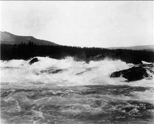 |
| Cascades of the Columbia. |
Priest Rapids was a narrow stretch where the Columbia River rapidly dropped 20 feet. Beyond the initial drop were six additional channels along a 9-mile stretch, over which the river dropped another 72 feet. The name came from Alexander Ross of the Pacific Fur Company, who in 1811 wrote of his journey to the "strong and rocky rapid" where he met a man "called Haquilaugh, which signifies…priest." Haquilaugh was an influential Wanapum leader, for whom Ross gave the rapids its English name.
 |
| Priest Rapids |
What the Dams Hath Wrought
Like everything else in life, the construction of the dams and inundation of the Columbia River Valley were a mixture of good and bad. One's evaluation of the effects usually depends on one's point of view.
On the plus side, the dams generate stupendous quantities of electricity from renewable resources. Unlike oil, coal and nuclear fuel, water is constantly recycling. Once used, water does not transform into a waste product. Instead, it rushes through each dam's gigantic turbines, generating electricity, then falling into the pool below the dam, eventually evaporating, turning into clouds, raining again into the river, recycling again and again. Without the hydroelectric power generated by these dams, the Pacific Northwest would almost surely be blanketed with either oil, coal or nuclear generating stations.
The dams and resultant reservoirs also make the Columbia navigable to freight-hauling barges. As the historical photographs indicate, the river was filled with impediments to travel. Portions were navigable when the water was high; others were never passable.
In 1875, after intense lobbying by steamboat interests losing revenue to railroads, Congress authorized construction of a canal and lock to allow water craft to navigate the Cascades of the Columbia, which until that time had been passable only by portage. The Army Corps of Engineers undertook what at the time was a terrifically difficult engineering project, completing it in 1896.
The canal was originally designed to be eight feet deep, fifty feet wide and 7,200 feet long with two locks. Shortly after work began in 1878, ice flow closed the river to all traffic, isolating the construction crew for months. In 1880, engineers changed the specifications because of an error made in calculating the low water mark. The new plans included only one lock, 90 feet wide, 462 feet long, with a lift of 36 feet.
The lock was designed to address the great variation in the height of the river from month to month. Three gates were designed, increasing in height from the lower entrance to the huge upper guard gate. Only two gates were used at any one time. When the river was low, the upper guard gates remained open continually and the lower sets were operated. When the water rose enough to inundate the lowest gate, it was left open and the lifting work was done by the other two.
Worked resumed on the project in 1886. Skilled masons cut stones for the canal walls. Unmortared basalt blocks three feet thick were laid above the high water mark to keep the river to the north from inundating the canal.
Because the river flooded each year in June, work was halted during the summer. Work commenced in the fall but was hampered with rain and snow. In 1888, the supervisor of the project noted: "A generation will have been born and gone to its grave between the beginning and ending of this enterprise."
After flood damage of 1894 was repaired, the canal finally opened in 1896 and remained in the use until 1937, when the Bonneville Dam was completed, flooding the lower gates in the lock. The upper gate, however, is still visible and part of Cascade Locks Marine Park in the city of Cascade Locks, Oregon. Your author has seen this park and believes that its primary function in the 21st century is for weddings and picnics, making one wonder if the cost and effort in the 19th century were worth it.
 |
| This image is taken from a 1915 picture postcard. The steamboat Bailey Gatzert is approaching the highest gate in the Cascade Lock. The vessel was taken off the river two years later. |
On the negative side, the damming of the Columbia River has had a horrible impact on the populations of both salmon and Native Americans. Although a single dam might have had relatively small impact on salmon, sea-run trout and other fish that spawn in fresh water, the cumulative consequences of 11 dams is enormous.
Basically, the creation of dams blocked salmon and other fish from swimming upstream to spawn. Various authorities have spent literally billions of dollars attempting to ameliorate this concern, mostly by constructing "fish runs" around the dams, but like ants evading even the most serious attempts at eradication, blockage on the Columbia River reappears over and over again.
At one time, about 15 million salmon and steelhead trout were estimated to return annually to the Columbia River Basin. Some current estimates are two percent of that -- around 300,000. Even though such estimates are subject to wide variation, no one disagrees that salmon populations have plumetted.
Advocates of the hydro-electric power industry argue that the primary cause of this decimation was commercial over-fishing occurring prior to construction of the first dam (Bonneville). Before 1850, Native Americans fished, traded and sold most salmon because they weren’t eaten by Europeans. However, after the development of salmon canning technology, huge operations like the Hudson Bay Company took over fishing in the Pacific Northwest. Salmon populations rapidly declined.
One of the worst offenders (from the salmon's viewpoint) was the so-called "Salmon Wheel," a huge circular drum with scoops that churned the waters, capturing spawning salmon by the thousands.
 |
| Salmon Wheel in Columbia River |
While over-fishing in the 19th century certainly was a contributing factor to the salmon's decline, the problem was recognized, and strict laws were passed in an attempt to eliminate, or at least contain, the problem. Salmon wheels were banned for commercial fishing in Oregon in 1929 and 1934 in Washington. Today (2020), commercial salmon fishing is closely regulated throughout the northern Pacific coast. For instance, because of depleted populations, salmon fishing has been banned in British Columbia in several areas for 2020.
Yet the decline of salmon populations continues. Although the "fish runs" discussed above have helped in allowing salmon to swim upriver, the reservoirs created behind the dams continue to impede the ability of juvenile salmon (smolts) to return to the sea.
Downstream migration can be fatally delayed by the time needed to drift and swim through multiple reservoirs. If smolts do not reach the sea within about 15 days after spawning, they lose their downstream swimming behaviour and their ability to switch from freshwater to saltwater. During dry years, smolts from the upper Snake River, the Columbia's main tributary, can take up to 39 days to swim to the sea, compared with less than three days before the dams were built.
The salmon's decline has brought especially deep hardship to Native Americans, peoples with a completely different concept of land than European Americans. European descendants, particularly those from Britain, believed strongly in the idea of private ownership of real property. Native Americans, on the other hand, generally held property either communally or not at all (and thus were migratory). These ideas were inconsistent; they could not coexist.
Natives called the Columbia River "Nch'I Wana." At Celilo Falls, they speared fattened fish returning upstream to spawn. When the spring thaw swelled the water, they moved downstream a few miles. In summer, when the river calmed, they moved back upstream.
Celilo Falls thus became a congregation of many peoples. Clark wrote:
"This is the Great Mart of all this Country. ten different tribes who reside on Taptate and Catteract River visit those people for the purpose of purchaseing their fish, and the Indians on the Columbia and Lewis's river quite to the Chopunnish Nation Visit them for the purpose of tradeing horses, buffalow robes for beeds, and Such articles as they have not. The Skillutes precure the most of their Cloth knivs axes & beeds from the Indians from the North of them who trade with white people who come into the inlets to the North at no great distance from the Tapteet."
On April 27, 1945, the Colonel in charge of the Portland District of the U.S. Army Engineers met with local Native Americans at The Dalles to listen to their concerns about the government’s proposal to build The Dalles Dam. In Wheels of Fortune, Francis Seufert, who attended the meeting, wrote:
“The Indian chiefs were all old men, very dignified. Each of the old chiefs came forward, one at a time, shook the colonel’s hand and talked through an interpreter giving the Indians’ story of their dependence on Columbia River salmon, and the serious effect that the building of the dam at The Dalles would have on the Indians’ livelihood. The old chiefs made many references to the Indian Treaty of 1855, the terms of the treaty and the obligations of the U.S. government to uphold the sacredness of the treaty and not build The Dalles Dam."After all the old chiefs had spoken, a number of the old women also addressed the colonel, these old Indian women telling the Indians’ side of the story of previous promises, and only receiving broken promises and excuses from the U.S. government. These old women pleaded with the colonel not to let that history from the Indian standpoint repeat itself again.“As I left the meeting and walked down the stairs, I couldn’t help feeling I had witnessed another bit of history in our government’s dealing with the American Indian, and I was sure of one thing at the time: if local merchants saw a chance to make money through the building of a dam at The Dalles, then nothing as simple as an Indian treaty signed some 90 years before was going to stand in the way.”
On Sunday, March 10, 1957, thousands gathered on high ground along the Columbia east of The Dalles to watch the birth of Celilo Lake and the death of Celilo Falls. At 10:00 a.m. the order to close the floodgates was given. The river's flow was so enormous that just four and one-half hours later, the reservoir behind the dam was filled, and the falls disappeared.
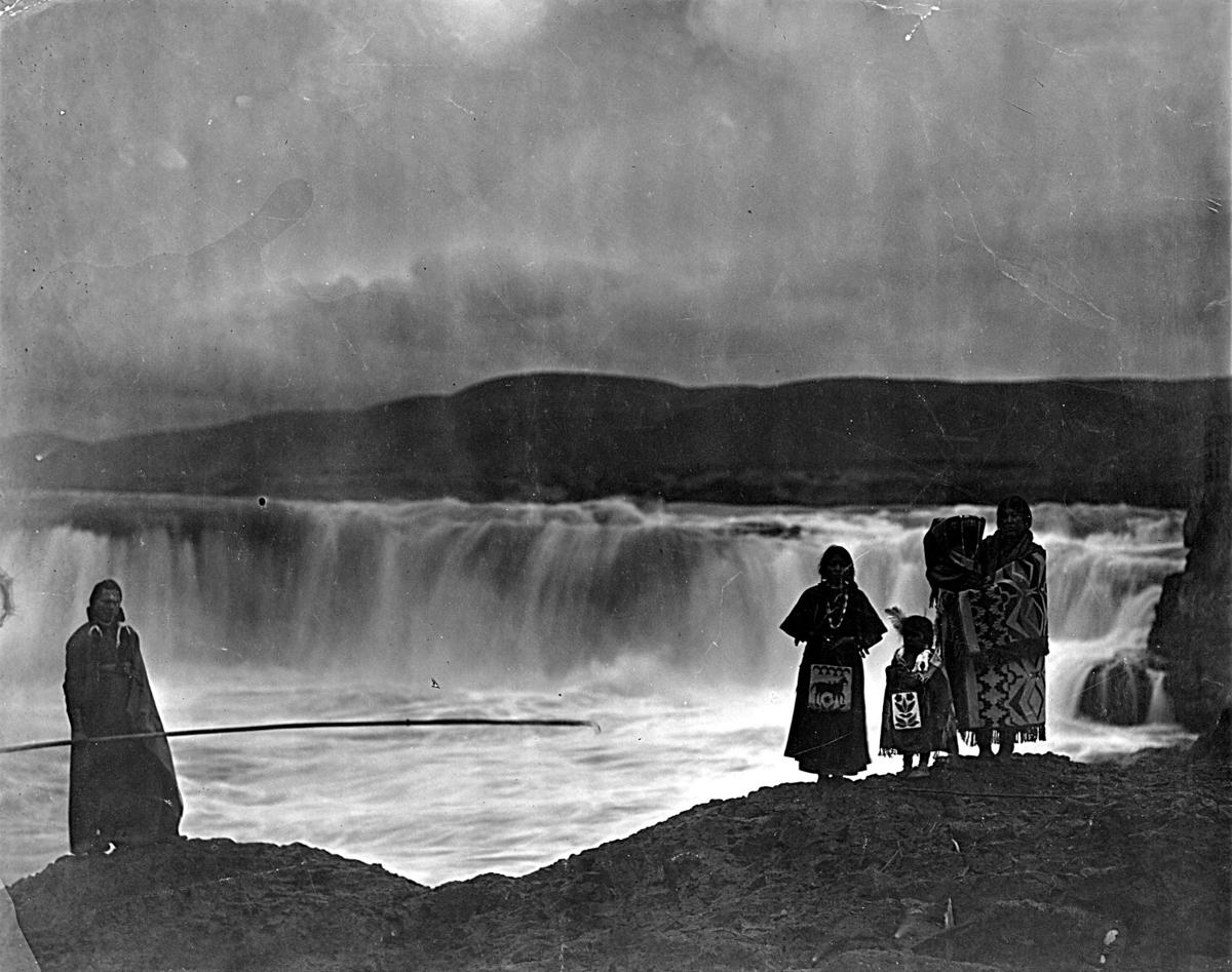 |
| Native American Family at Celilo Falls. |
A Brief Rail History of the North Shore of the Columbia River
At the beginning of the 20th century, the Union Pacific controlled the south bank of the Columbia River, thereby obtaining direct access to Portland, the largest city in the region at that time. The Northern Pacific had gained access to Portland via Puget Sound to the north. The Great Northern had no access at all.
The north bank of the Columbia River, however, was vacant of both railroad and highway. The Milwaukee Road was working its way across Montana, preparing to cross the Bitterroots, looking for access to the Pacific Ocean. The Northern Pacific also desired the route, believing that it would provide easier and more profitable access to the Willamette Valley. The Union Pacific, with a monopoly on traffic directly in and out of Portland, feared construction on the north bank by any company.
James J. Hill, the Empire Builder of the Great Northern, announced in 1905 a plan for a railroad to be constructed jointly (by the Great Northern and Northern Pacific) along the north bank of the Columbia. The railroad was to be called the Portland and Seattle, later changed to the Spokane, Portland and Seattle. The tracks would follow the river east as far as Kennewick, Washington, along the curvature of the mighty stream as it turned north toward Canada, then cross the water into Pasco, then along the edge of the Palouse into Spokane.
Because the line was on the north shore of the Columbia, in Washington, construction involved three major new bridges to reach Portland, crossing the Columbia River, the Oregon Slough and the Willamette. The bridge into Oregon was the first across the lower Columbia.
Construction was completed in 1908; the "golden spike" was driven at MP 50.5 near North Bonneville, Washington. Soon thereafter, Hill announced plans to build the Oregon Trunk Railroad from the SP&S mainline at Wishram, Washington, to Bend, Oregon, and a connection with the Western Pacific.
A Union Pacific Subsidiary -- Oregon & Washington Railway & Navigation Company -- also began construction of a line to Bend, resulting in a short-lived "railroad war." The Oregon trunk built on the west bank of the Deschutes River, the Oregon and Washington on the east. Eventually, the Oregon and Washington opened, using mostly the track of the Oregon Trunk, with a short portion of the Oregon & Washington track south from the Deschutes River.
The Oregon and Washington track was eventually abandoned and today serves as a hiking trail, providing excellent views of the Oregon Trunk across the river. At one time, UP had trackage rights on the line to Bend, but in June 2020, the transfer track from UP mainline to Oregon Trunk was covered with rust and appeared to be abandoned.
The Spokane, Portland and Seattle continued independent operations until the 1960s' merger creating Burlington Northern. The last engines ordered by the SP&S from EMD were delivered in BN Cascade Green. The route along the north shore of the Columbia River was one of the best engineered that BN inherited, and today it is the primary Portland mainline of BN's successor BNSF.
The Photographs
The following images proceed from west to east, from the edge of the temperate rain forest to the almost-desert past Wishram, Washington. Along the way, brief discussions will be found concerning the geology of the Columbia River, geology of Mount Hood, characteristics of various reservoirs, relocation of the rail line due to inundation of the river valley, and assorted other topics.
West of Bingen
 |
| An eastbound stack train waits for a new crew at Cooks Siding, about eight miles west of Bingen (rhymes with "engine"), Washington. |
 |
| Westbound stacks about three miles west of Bingen. Vegetation on the ground is thick with firs and pines, but the hills above, several miles to the east, are spotted with grassy meadows. |
Look Lake
 |
| A few miles east of Bingen, the BNSF line crosses the water on a long, curving causeway. Beyond the causeway is Lake Bonneville, impounded by the Bonneville Dam, about 30 miles downstream. Behind the causeway, cut off by the tracks from the main body of water, is Look Lake. In the image above, Mount Hood towers over the eastbound Portland section of Amtrak's Empire Builder. |
 |
| Westbound, loaded grainer crossing the same causeway. Grain trains are frequent on this line, accounting for more than 30 percent of total traffic. |
 |
| Pushers on a loaded, westbound coal train. Coal also constitutes significant traffic, perhaps as much as 20 percent. |
 |
| This rainbow is looking down upon a westbound garbage train at Look Lake. Such trains are also frequent occurences. |
 |
| Eastbound Amtrak on causeway beside Lake Bonneville. |
 |
| Eastbound manifest loaded with finished lumber. At one time, the Columbia River Gorge was lined with saw mills. However, a large stretch of the river has been designated a National Scenic Area, and most of the mills have closed. |
 |
| Eastbound manifest beneath Mount Hood. |
 |
| This eastbound manifest on the causeway at Look Lake was pulled by seven units, only two of which appeared to be loading. The seventh still retained its original AT&SF colors. I followed this train one morning for about 60 miles. Images of it will recur below. |
 |
| Another eastbound manifest towing additional power beside Look Lake. The two units in the rear have been recently repainted but bear no markings. Your author does not know where they were headed. |
 |
| An eastbound empty grainer is leaving the causeway at Look Lake. |
Chamberlain Lake
 |
| A few miles east of Look Lake sits the Chamberlain Lake Rest Area off of Washington State Highway 14. The railroad bores through four short tunnels at this spot. One is shown above. |
 |
| Pushers on a loaded coal train are entering one of the Chamberlain Lake tunnels. The lake itself is in the foreground, another small body of water created by a BNSF causeway, beyond which lies Lake Bonneville. The whitecaps on the big lake are indicative of the fierce breezes ("gales" may be closer to the correct description) that often blow through the Gorge, making the location a favorite for wind surfers. |
 |
| An eastbound garbage train on the causeway at Chamberlain Lake. |
Lyle
 |
| Westbound stacks are "in the hole" at Lyle Siding. |
Murdock
 |
| At a tiny settlement called Murdock, the tracks turn south toward Dallesport, while Washington 14 continues east. Here the seven unit train with AT&SF bringing up the rear is leaving the highway. |
 |
| Westbound coal at Murdock. |
 |
| Westbound autos. Image taken from across Lake Bonneville. |
 |
| Eastbound empty grainer passing westbound barge. Train is about halfway between Bingen and Dallesport. Notice the lack of vegetation. Average rainfall here is about 17 inches per year. Barge traffic is moderate through the various lakes -- a trickle compared to rail. |
 |
| Westbound loaded coal has just passed Murdock. |
 |
| Westbound Amtrak at Murdock. |
 |
| Westbound garbage. |
Horsethief Lake
 |
| As discussed above, at Murdock the tracks run south to Dallesport, then make a 180 degrees turn back to the north before running across another causeway that creates Horsethief Lake. Washington 14 runs east, eventually overlooking the causeway at Columbia Hills State Park. The image above shows a westbound loaded coal train on the causeway. Across the water are the Union Pacific mainline and Interstate 84. |
 |
| Pushers on westbound grain at Horsethief Lake. Beyond the causeway is Celilo Lake, created by The Dalles Dam. Beyond Celilo Lake are passing UP stacks. At this location, the UP tracks run between opposite lanes of I-84. |
 |
| Eastbound stacks and trailers at Horsethief Lake. |
 |
| Mid-trains at Horsethief Lake. |
 |
| Another westbound grainer -- Horsethief Lake. |
 |
| Trucks, barges and trains -- on I-84, Celilo Lake and Horsethief Lake Causeway. Notice at this location the complete lack of bushes and trees, save for the water's edge. |
 |
| Pushers on a westbound grainer are leaving the Horsethief Lake causeway. |
 |
| Westbound coal load. |
Avery
 |
| East from Horsethief Lake we find Avery, Washington, not a town but a location on the railroad just west of the Oregon Trunk Bridge -- a collection of four tracks where trains waiting for crews are often parked. From a highway turnout above the tracks, one can take this image, with Mount Hood glowering in the background. Mount Hood is a volcano, one of several that line the Pacific Northwest (the "Cascade Volcanoes") formed by movement along the Cascadia subduction zone, from Mount Tehama in California to Silverthrone Caldera in British Columbia -- 88 in all, including Mount St. Helens. Mount Hood stands 11,240 feet and is considered active and dangerous. The last eruption occurred in 1907. According to the U.S.G.S.: "A significant eruption of Mount Hood . . . would displace several thousand residents and cause billion-dollar-scale damage to infrastructure and buildings." To give you some idea of how massive this volcano is, it stands over 40 miles from the photographer in the image above. The photographer does not want to be anywhere nearby during the next eruption. |
 |
| Amtrak at Avery. |
 |
| A westbound grainer is passing two parked manifests at Avery. In the distance, two light engines are headed to the yard at Wishram. Behind the light engines stands the Oregon Trunk Bridge. |
 |
| Eastbound at Avery. |
 |
| DPUs on westbound grain. |
 |
| A nine unit eastbound approaching Avery. |
Oregon Trunk Bridge
 |
| A BNSF "bare table" is crossing the Oregon Trunk bridge before turning northeast to Pasco, Washington. The bridge piers are footed on rocks which were normally exposed during low water periods on the Columbia. The Celilo Canal passed below the southernmost span, which would swing open to allow water traffic. When the Dalles Dam created Celilo Lake, the canal was inundated, the swing span was locked and a new lift span was constructed to allow the passage of barge traffic on the higher water level. |
 |
| An eastbound barge is passing through the lift span of the Oregon Trunk Bridge. To the right of the barge is one wall of the now inundated Celilo Canal. To the right of the canal wall is the old swing span now locked in place. |
 |
| Here is an image of the full bridge. The north end wyes so that trains from Oregon can turn either west to Portland or east to Pasco. Passing beyond the wye are westbound autos. |
 |
| The pusher on a southbound BNSF manifest is crossing the old Celilo Canal. |
 |
| A short BNSF Office Car Special begins passage north across the bridge. |
 |
| Westbound Amtrak at Oregon Trunk Bridge. |
Wishram
 |
| Nestled in a small depression between basalt cliffs, Wishram, Washington, is a classic railroad town. In the image above, an empty eastbound grainer is rolling to Pasco. The houses in the bluffs above the river are known to the locals as Wishram Heights. There is one small church in town. When your author passed through on a Sunday in June 2020, a service was being held in the small parking lot. Two women and a man were playing guitars and singing into a single microphone connected to a dilapidated public address system. Worshippers were sitting in six or seven cars and pick-ups. Your author stopped, asked why everyone was sitting in the parking lot -- like an old time "drive in" movie -- and was told that everyone was scared of contracting "the virus." |
 |
| An eastbound manifest is passing westbound trailers in Wishram. In the background is the Oregon Trunk Bridge and the connection with the old Oregon Trunk Railroad, which provided the rationale for locating a yard at Wishram. From this view, one can easily see how the Columbia River Gorge was scoured by repeated floods during the last ice age, as ice dams froze, then broke, then froze and broke again, over and over, releasing Biblical floods from ancient Lake Missoula. (For a more complete discussion of Lake Missoula, see https://www.waltersrail.com/2020/08/canyons-plus-deep-dive-into-esoterica.html and https://www.waltersrail.com/2016/04/bnsf-up-and-mrl-in-idaho-panhandle.html.) |
 |
| A loaded westbound coal train is coming into the yard at Wishram. |
 |
| Same train. |
 |
| Amtrak at Wishram. |
Line Relocations
 |
| East of Wishram, the old Spokane, Portland and Seattle line was relocated because of the inundation of the Columbia River Gorge. This image was taken just downstream from the John Day dam. The photographer is standing near the water's edge. To keep the grade manageable, the line has been relocated on a fill about 60 feet tall. |
 |
| Downriver from the Sam Hill Memorial Bridge (a portion visible in the upper right) the line relocation is more moderate. The old roadbed is visible nearer the water and is traversable in a Jeep. |
 |
| Your author likes to include at least one image taken under adverse conditions. All hell broke loose (raindrops as big as grapes) as the shutter snapped for the image above. The author is standing on the old roadbed. The author's camera is waterproof. The author is not. |
John Day Dam
 |
| Construction commenced on the John Day Dam in 1968 and was completed three years later, impounding water to create Lake Umatilla. The tracks originally ran where the lock beyond the train (between the train and the white water) was constructed. The relocated line runs along another high embankment. |
 |
| John Day Dam with westbound BNSF stacks and an eastbound barge approaching the lock (on the near bank). |
 |
| A barge is entering the John Day lock. BNSF trailers run east. Across the water, UP stacks run west. |
 |
| Pushers on a loaded coal train on the high water side of the John Day Dam. |
 |
| Front end power of the same train. |
 |
| Upriver from John Day Dam on Lake Umatilla. The electric lines in the foreground are carrying hydro-electric power to the northeast. |
 |
| Westbound oil train at Towal Siding -- east of John Day Dam. |
 |
| A westbound garbage train approaching John Day Dam. In the foreground is one of many areas along the Columbia River reserved for Native American fishing -- established by the legislation that appropriated the land inundated by the various dams. Not exactly an even trade. |
Goodnoe
 |
| Shortly after passing John Day Dam, eastbound trains turn hard to the southeast at a location marked Goodnoe on the map, though as nearly as your author can tell, there is nothing at Goodnoe except railroad tracks. Here the nine unit manifest pictured earlier is making the turn. |
 |
| Westbound autos at Goodnoe. |
 |
| Eastbound grainer beneath high tension electric lines and windmills, both of which look like an invasion of alien insects. |
 |
| Same train. |
 |
| DPU on the same train. |
Bates
 |
| After running southeast, the tracks turn back due east again at Bates. Here the power of a loaded coal train has just cleared the west switch of the siding. |
 |
| The nine unit train is clearing the east switch at Bates. |
 |
| Pusher on eastbound stacks just west of Bates Siding. |
 |
| Eastbound stacks approaching Bates. |
Roosevelt
 |
| Beyond Bates to the northeast lies the unincorporated village of Roosevelt, home to the Roosevelt Regional Landfill, one of the largest landfills in the United States. BNSF maintains a facility there for the off-loading of garbage containers. Above a BNSF garbage train approaches Roosevelt. BNSF 276 is an SD751 originally painted in the Warbonnet scheme. Here it is in its recently repainted glory (June 2020). |
We have come to the end of our eastward journey along the Columbia Lakes. Your author hopes to visit more northern reaches in the not too distant future (including the old Plutonium factory at Hanford, Washington) and will file a report to commemorate the trip (assuming your author does not meet with intervening untoward circumstances). Until next time:
To see my other posts, go to waltersrail.com.
To see my photographs on Flickr, go to https://www.flickr.com/photos/jpwalters/.
The following chart lists in alphabetical order (1) names of the 11 dams on the Columbia River in the United States, (2) operators, (3) dates of construction commencement, (4) dates of opening and (5) names of reservoirs impounded:
1. Bonneville:
A. Operator: Army Corps of Engineers
B. Construction Commenced: 1934 (First Powerhouse); 1974 (Second Powerhouse)
C. Opening date: 1937 (First Powerhouse); 1981 (Second Powerhouse)
D. Reservoir Impounded: Lake Bonneville
2. Chief Joseph:
A. Operator: Army Corps of Engineers
B. Construction Commenced: 1949
C. Opening date: 1979
D. Reservoir Impounded: Rufus Woods Lake
3. Dalles:
A. Operator: Army Corps of Engineers
B. Construction Commenced: 1952
C. Opening date: 1957
D. Reservoir Impounded: Lake Celilo
4. Grand Coulee:
A. Operator: Bureau of Reclamation
B. Construction Commenced: 1933
C. Opening Date: 1942
D. Reservoir Impounded: Lake Roosevelt
5. John Day:
A. Operator: Army Corps of Engineers
B. Construction Commenced: 1968
C. Opening Date: 1971
D. Reservoir Impounded: Lake Umatilla
6. McNary:
A. Operator: Army Corps of Engineers
B. Construction Commenced: 1947
C. Opening Date: 1954
D. Reservoir Impounded: Lake Wallula
7. Priest Rapids:
A. Operator: Grant County Public Utility District
B. Construction Commenced: 1956
C. Opening Date: 1961
D. Reservoir Impounded: Priest Rapids Lake
8. Rock Island:
A. Operator: Puget Sound Energy
B. Construction Commenced: 1930
C. Opening Date: 1933
D. Reservoir Impounded: Rock Island Pool
9. Rocky Reach:
A. Operator: Chelan County Public Utility District
B. Construction Commenced: 1956
C. Opening Date: 1971
D. Reservoir Impounded: Lake Entiat
10. Wanapum:
A. Operator: Grant County Public Utility District
B. Construction Commenced: 1959
C. Opening Date: 1963
D. Reservoir Impounded: Lake Wanapum
11. Wells:
A. Operator: Douglas County Utility District
B. Construction Commenced: 1963
C. Opening Date: 1967
D. Reservoir Impounded: Lake Peteros
Construction on John Day began in 1958; not 68
ReplyDelete