 |
| Powder River Basin -- Wyoming
When I remember the Burlington Northern, I think of a gigantic mechanical shovel, like a tyrannosaur, gouging coal out of the Wyoming badlands, larger than life, larger almost than imagination, and I wonder, "Who dreams so big?" My dreams are modest, at best -- a wish for good health, a desire not to be laughed at, a hope to stay out of history's way and live in peace.
But not the Burlington Northern. It was arguably the first mega-railroad, with over 26,000 miles of track (excluding subsidiaries Colorado and Southern and Fort Worth and Denver), the combination of four lines all monsters in their own rights -- Great Northern; Northern Pacific; Chicago, Burlington and Quincy; and Spokane, Portland and Seattle. These roads had tried through most of the twentieth century to merge, and were turned down three separate times by the sclerotic Interstate Commerce Commission. When I remember the ICC, I think of a gigantic yellow banana slug moving laboriously and pointlessly across a landscape devoid of all other life.
On March 2, 1970, when all four parent roads were struggling for survival, when the acrid odor of the Penn Central was as pungent as a rendering plant, the Burlington Northern was born. Seen as the only hope to salvage the parents, the railroad initially ran deeply in debt -- a condition facing all but a handful of railroads in 1970. With the passage of 1970's Clean Air Act, cleaner burning Powder River Basin coal suddenly became in great demand, and the Burlington Northern just happened to have a line running through the coal fields. The transformation to significant profitability was as sudden as it was astounding, and the Burlington Northern continued to make money until its merger in 1995 with the Atchison, Topeka and Santa Fe, creating an even more gigantic carrier to compete with the by then (through various acquisitions) gargantuan Union Pacific. By this time the banana slug was dead.
|
 |
| Powder River Basin -- Wyoming
Because of the lack of contextual images, this drag line appears reasonably sized, but that is an illusion. If you look beneath "Antelope Coal Co." you will see a catwalk with railings almost as tall as a human. That gives some idea of this behemoth's size. Because it strip-mined coal for another behemoth to haul away, shovels like this always seemed at home on the endless, treeless badlands of eastern Wyoming.
It is not my intent to focus exclusively on Wyoming coal. I start there because of the metaphor. This post will explore various facets of the Burlington Northern up to its merger with the Santa Fe. I have published three previous posts on this railroad, involving Nebraska's Sand Hills; Crawford Hill; and the line in southern Colorado from Trinidad to Walsenburg. That information will not be repeated:
https://www.waltersrail.com/2016/06/burlington-northern-trinidad-to.html;
https://www.waltersrail.com/2016/12/burlington-northern-at-crawford-hill_13.html; https://www.waltersrail.com/2018/03/nebraskas-sandhills-in-transition.html. Also, the following images are not presented in any particular order. They appear randomly as my computer has generated them. The intent, if successful, is to create an impression rather than a discussion, something like a thought that occurs early in the morning when one is neither fully asleep nor fully awake. If, on the other hand, I am unsuccessful, you will no doubt grow bored quickly and stop reading. Either way, I will not have wasted much of your time. |
 |
| Somewhere in Western Nebraska
I do not remember exactly where this image was taken, and I can find no notes. In the background are small, stabilized sand dunes, making me think we are either in or very near the Nebraska Sand Hills. What I do remember about this photograph is that I took it shortly after being stopped by a Nebraska state trooper. I was driving about 80 miles per hour in an attempt to reach a budget motel (the name of which I no longer remember) before sundown -- an important deadline, because the owner had told me by phone that she locked the office door and went to bed at that hour. How she remained in business I do not know.
The officer pulled me over and asked to see my driver's license. Just as I handed it to him, I saw the headlights of an approaching westbound train.
"Excuse me," I said, "but do you mind if I walk across the highway and take a photograph of that train?"
He looked at me as though I had a communicable disease and said, "Well, I guess it's okay. Honestly, no one's ever asked me that before."
I quickly hopped across the road, took the image and returned to my vehicle. He asked why I was driving so fast, and I told him. He gave me a warning, no ticket. I think he felt sorry for me.
|
 |
| Weston, Missouri
The train on the right has stopped, preparing to come off the spur from the generating station of Kansas City Power and Light at Weston, Missouri. The train in the middle is a loaded, southbound coal train with a Kansas City Southern White Knight on the point, waiting in the passing siding. The train on the left is the only one in motion -- an empty, northbound coal train. This area is now double track, so the odds of a shot like this today (April 2019) are pretty slim.
|
 |
| Carlyle Lake, Illinois
An empty, northbound coal train is crossing Carlyle Lake on Burlington Northern's Beardstown Subdivision, a once obscure branch line that became a major coal hauler. Carlyle Lake is about 50 miles east of St. Louis and at 26,000 acres is the largest lake wholly contained within Illinois.
The subdivision was named for Beardstown, Illinois, about 100 miles north of St. Louis, running southeast from that town to Metropolis, Illinois, and Paducah, Kentucky, serving power plants along the route. In Paducah, some coal was transferred to barges on the Ohio River for further transport.
|
 |
| Palmer Lake, Colorado
A northbound empty coal train is coasting downgrade at Palmer Lake, Colorado. The line in the foreground was operated by the Denver and Rio Grande Western at the time (1983). The southbound grade for loaded coal trains required helper units, and the tracks were easily accessible for photography.
|
 |
| Northwest Nebraska
This empty coal train, bound northwest for the Power River Basin, is passing through stabilized sand dunes between Alliance and Crawford, Nebraska. Both SD70MACs are painted in Grinstein Green, named for Gerald Grinstein, the CEO of Burlington Northern from 1985 to 1995. Originally, this scheme was applied to the F-units of the railroad's executive office car train. The scheme was later employed for BN's last locomotive order before the merger with Santa Fe -- EMD SD70MACs.
|
 |
| Near Ravenna, Nebraska
A loaded coal train passes an empty on a passing siding in the central Nebraska Corn Belt. (Today the line is double-track.). The two blue and white Oakway units were owned by EMD, and Burlington Northern, in an industry first, purchased "power by the hour" from SD60s built in 1986 and leased to Oakway, Inc., a subsidiary of Cornell Rice & Sugar. Instead of leasing locomotives from a bank or equipment leasing company, BN purchased only the electrical energy exerted by the locomotives.
|
 |
| Mullan Pass, Montana
We are in Montana now, at the famed Mullan Pass, the line across which (when this image was taken in 1994) was not owned by the Burlington Northern. The line was originally constructed by the Northern Pacific and became part of the Burlington Northern upon approval of the merger in 1970. However, the railroad later sold the trackage to a new company -- Montana Rail Link -- totally dependent on the BN for interchange traffic on both its eastern and western terminals. This line ran through some of the most beautiful parts of Montana. I include images from MRL trackage in this post, because many trains across that railroad were hauled by Burlington Northern motive power.
Like so much of 19th century American history, the story of the Northern Pacific involved greed, anger, high finance, bankruptcy, controversy, disaster, triumph, then more disaster. Since construction began only a short time after the original transcontinental line along the 42nd parallel, one might wonder about the need for a second line across the western mountains. Well, even though the country was engaged in a horrific civil war, there was still money to be made and politicians to aid in the making. The push to build a second transcontinental railroad was led, not surprisingly, by Northern senators and especially by Josiah Perham, an Eastern railroad promoter. He lobbied Congress like a small dog in search of a meal and eventually secured a federal charter for the Northern Pacific Railroad Company. This bill later passed both houses of Congress and was signed into law by President Lincoln on July 2, 1864. While the Northern Pacific never gained the notoriety of the Union Pacific, the former was unique in one very special way. It was the first railroad built across the West without government financing. The noted banker Jay Cooke initially obtained several million dollars in private financing, and the gateway from Lake Superior to the Pacific Northwest seemed primed to open. However, like so many 19th century railroad enterprises, this one ran up against the cold reality of the Rocky Mountains. Construction across Minnesota and the Dakota Territory was one thing. Even the first third of Montana was relatively tame. But at some point the railroad faced the same dilemma as the Lewis and Clark expedition, the path of which the Northern Pacific followed closely. As Lewis and Clark discovered, when you cross one mountain range in Montana, you find another. Then another, as though God created Montana solely to frustrate and ultimately bankrupt all railroad construction. And that's what happened to the Northern Pacific. Montana was like a razor-wire fence. You could not dig under it. You could not slide around it. And you could not climb over it without significant effort and injury. The railroad went bankrupt before completion but was ultimately rescued by private financiers looking to buy low and sell high. The locating engineers marked a route across Bozeman Pass, then turned north and followed the Missouri River through Lombard Canyon, still today one of the most magnificent railroad locations in North America. The line continued north, eventually turning west again to reach Helena, past which lay the Western Continental Divide, surmounted at Mullan Pass. The railroad then followed the Clark Fork River to Missoula and beyond to St. Regis, where the tracks and river turned north, avoiding the Bitterroot Mountains, trending northwest all the way to Lake Pend Oreille in Idaho, crossing the lake at what later came to be called "The Funnel" when the Great Northern several years later also crossed at the same point, then heading to Washington through a gap in the mountains created by flooding from the ancient Lake Missoula. (For a more complete discussion on this geological feature, go to: https://www.waltersrail.com/2018/08/lake-pend-oreille-or-importance-of.html. . |
 |
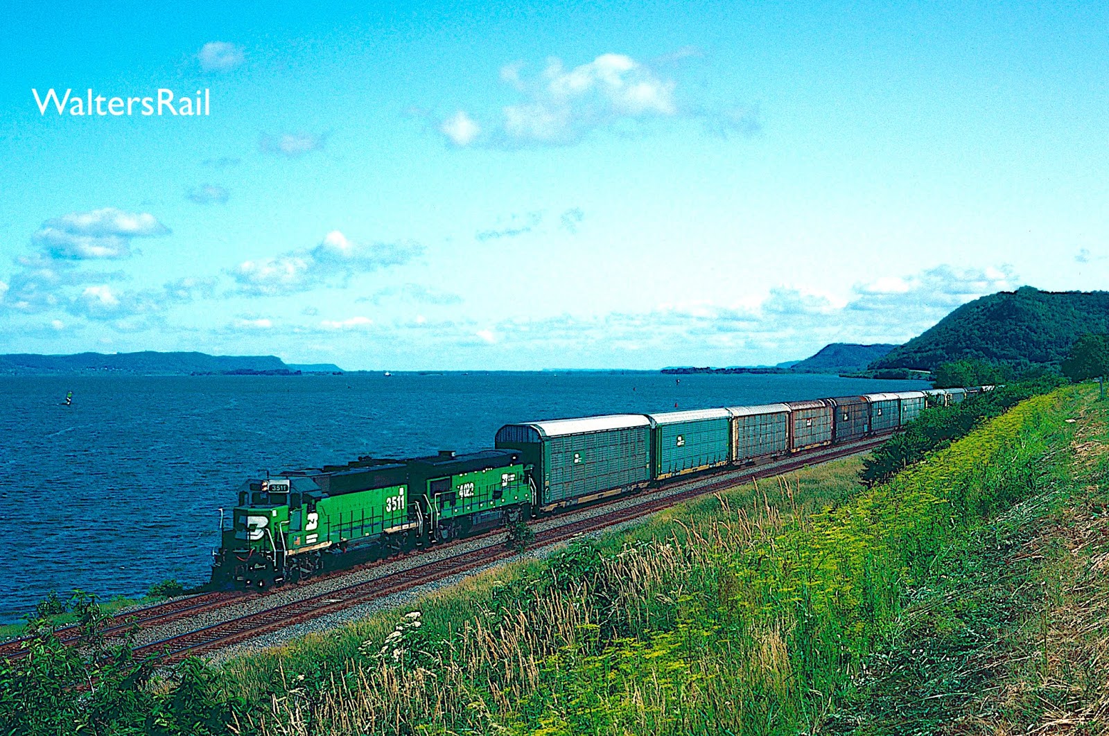
| Berwyn, Nebraska
No, this photograph of a meet was not taken after the merger but rather in 1994. At that time, it was common to find Santa Fe power running on BN trackage to the Powder River Basin. This is another portion of the line to Wyoming that is now double-track.
|
 |
| Mississippi Palisades State Park, Illinois
This state park is located in the bluffs high above the Mississippi River in northwest Illinois, about 135 miles from Chicago. Slightly south of the park, at Savanna, Illinois, where the Plum River flows into the Mississippi, a line running north along the river joined the mainline from Chicago to La Crosse, Wisconsin, and ultimately the Twin Cities. When this image (and others in this post from the same area) was taken, the line north of Savanna was dispatched with track warrants, so it was easy to find trains by listening to dispatchers talking to crews coming from all directions.
This line was originally part of the Chicago, Burlington and Quincy. A map of that system, circa 1950, is reproduced below: |
 |
| As this image shows, most of the photographs in this post were taken on lines originally operated by the CB&Q. For example, find St. Louis on the map and the route north to Hannibal, Missouri. That is the "K Line," images of which will appear in due course. Now go east of St. Louis to Centralia, Illinois, and you will have discovered the Beardstown Subdivision, a little-used branch line that became a major coal hauler in the 1970's. North of Colorado Springs, Colorado, is the big hill at Palmer Lake. Gillette, Wyoming, in the northeastern corner of the state, is the northern entrance to the Powder River Basin. The line through Broken Bow, Nebraska, in the center of the state became a major coal artery to the East and South. The line north of Kansas City served the power plant at Weston, Missouri, and carried coal destined for Oklahoma and Texas. West from Chicago, you will find the line to Savanna, Illinois, and Mississippi Palisades State Park. As you can see, the line turns north and follows the Mississippi River all the way to the Twin Cities in Minnesota. Later in this post, we will find images taken along the same line at La Crosse, Wisconsin. Notice also how the CB&Q interchanged neatly with the Northern Pacific in the Twin Cities and in southeastern Montana. Following is a map of the Northern Pacific from the 1953 Official Guide, showing that the two railroads were perfect mates. |

 |
| Mullan Pass, Montana
Here is another Burlington Northern run-through freight on MRL tracks at Mullan on the old Northern Pacific. The train is just making the turn to Mullan Trestle and will soon enter the tunnel near the top of the grade. The original construction, to save time, bypassed tunneling in favor of multiple switchbacks up the hill to the Western Continental Divide. Some of the switchbacks are still visible if you know where to look. Later the tunnel was drilled, the height and width of which were much later enlarged in the early 21st century to provide more oxygen to keep engines from powering down, to allow for double-stacks to pass with reasonable clearance, and also to provide room for trains crews to walk beside a stalled train to check for broken air hoses and/or knuckles. I once witnessed a loaded coal train's stalling inside the tunnel with a broken knuckle, which the crew located and repaired by flashlight!
|
 |
| East of Livingston, Montana, on the Yellowstone River
LMX/LMS was a GE leasing subsidiary that owned 100 B39-8's which were leased on "power-by-the-hour" to BN on the same basis as the Okay units. "Power-by-the-Hour" was an attempt to bypass union contracts that barred the contracting out of locomotive maintenance. I believe the union prevailed in the subsequent labor dispute, which probably explains why the concept never went beyond LMX and Oakway.
This is another portion of the old Northern Pacific and runs in the valley of the Yellowstone River from Livingston to Billings, Montana, and beyond. Although not technically in the mountains, the line provides spectacular scenery and is followed closely by Interstate 90, and in many places old US Route 10, such that wonderful photographic locations are easily accessible. |
 |
| Somewhere in North America I like this image, but I have no idea where it was taken. The target signals make me think this was originally a Frisco line, perhaps from Tulsa to Dallas, but the landscape is unfamiliar. The CB&Q also employed target signals, however, so my wild ass guess may be like most of my other wild ass guesses -- wrong. |
 |
| Loaded Southbound Coal at Weston, Missouri
On the CB&Q, this was a single track line connecting Kansas City and Omaha and saw moderate traffic, at best. Like its more well-known cousin north of Savanna, Illinois, this route followed the valley of a major river -- in this case the Missouri. Several geographers believe that the Missouri River actually runs all the way to the Gulf of Mexico, and that the Mississippi River actually flows into the Missouri north of St. Louis, not the other way around. If this view had been accepted, the Missouri River would be one of the longest in the world. Once the "coal rush" started in the 1970's, this BN line north of Kansas City was overwhelmed with Powder River traffic and eventually double-tracked.
|
 |
| BN 8076 East attacks the grade on MRL trackage -- west side of Bozeman Pass.
Here is another location on the old Northern Pacific -- the western slope of Bozeman Pass, one of the more historic areas in Western American history. While encamped on July 13, William Clark wrote in his diary, “The Indian woman who has been of great service to me as a pilot through this country recommends a gap in the mountain which I shall cross.” The "Indian woman" was Sacagawea, who led the party between the Bridger and Gallatin mountain ranges through Bozeman Pass, following a “well beaten buffaloe road” to “the top of the dividing ridge between the waters of the Missouri from those of the river Rochehone [Yellowstone].”
The pass had been used for thousands of years prior to Clark's crossing, particularly by Native Americans who followed bison migrations. In 1883, the Northern Pacific built across the pass. An automobile highway, the Yellowstone Trail, was constructed in 1912, replaced in 1926 by US 10, and then in 1956 by Interstate 90.
|
 |
| LMX 8583 West is climbing the eastern slope of Bozeman Pass.
In my experience the western slope of the pass is more amenable to railroad photography in the summer, while the eastern side is preferable in the fall and winter -- especially if you like to chase trains up mountain grades. On the eastern slope in summer, Interstate 90 is on the south side of the tracks (running approximately east/west) while the sun is to the north. Thus, to chase a train, one must stop along the interstate, climb across the tracks to the north, take a shot, then wait for the entire train to clear before returning to one's vehicle, severely limiting the number of available shots.
At the summit, however, the tracks cross underneath the highway, so the road is now north of the tracks -- the same as the sun. Accordingly, chasing a train up the western slope in summer does not require crossing the tracks, then waiting for the train to clear, providing access to many more potential shots.
In the fall and winter, the position of the sun is reversed -- now south of the tracks -- making the eastern slope more favorable for chasing.
|
 |
| At dusk, Grinstein 9548 roars south of Centralia, Illinois, with a loaded coal train -- Beardstown Subdivision.
Centralia, Illinois, is a fascinating railroad town, because three mainlines intersect there in a settlement that looks a little like one of the crossroad villages in the Ardennes of Belgium -- the old Illinois Central mainline from Chicago to New Orleans, now operated by Canadian National; the old Southern Railway mainline to East St. Louis, Illinois, now operated by Norfolk Southern; and the old CB&Q line to Paducah, Kentucky, now operated by BNSF. I lived in Belleville, Illinois, for several years and would often on a weekend drive east to Centralia and spend the day watching and chasing trains. My memory is that I would reliably see at least one train per hour, and often two or more.
Centralia is also of interest to me because my mother lived there for a short time. Her father was an itinerant oil field worker from Oklahoma who moved from town to town to find work. At one time in the 1930's, there was a small oil play in and around Centralia, and my mother and her parents spent about nine months there. My mother remembers it being very cold and snowy in the winter, and I can vouch for that. The flatlands of south central Illinois can produce some monstrously cold weather in January and February.
|
 |
| Hannibal, Missouri
A loaded coal train rolls through Hannibal, Missouri, on Burlington Northern's Hannibal Subdivision -- also known as the "K Line." The Mississippi River has flooded into town and along the tracks. In the background, beyond the highway bridge, is the vertical lift bridge of the old Wabash Railroad (now Norfolk Southern). On the Missouri side, the tracks turn due south and traverse a short tunnel through the bluffs.
This image was taken from a public park on top of the bluffs. The photographer climbed a fence to obtain the best angle for the shot. While he was waiting for the train, a police car drove up, an officer climbed out, an overweight fellow with a face almost as round as a pie tin, and told the photographer to come back to the fence. "So just exactly what are you doing?" the officer said -- or something like that. This was about 25 years ago. "Photographing that train," the photographer replied, pointing in the direction of the approaching headlight that had just come under the highway bridge. "What?" "Photographing that train." "Why?" "It's my hobby." This response seemed to confuse the officer, as though it had never before occurred to him that someone would climb a fence in a public park, inch out onto a ledge about 100 feet or so above the surrounding flood plain, and take a photograph of a moving coal train. "Well," he finally said, "we had a fellow commit suicide by jumping off this ledge last week. You're not going to commit suicide, are you?" The photographer replied that he might be crazy, but he wasn't that crazy. The officer's expression made it clear that he was not so certain about that, but he allowed the photographer to remain on the ledge and take the above image. |
 |
| Jones, Oklahoma
The daily Tulsa to Oklahoma City freight is approaching Jones, Oklahoma, on a line operated for years by the St. Louis and San Francisco Railroad -- before the Burlington Northern absorbed it. When the BN and AT&SF merged, this line became redundant and was sold to the State of Oklahoma, then sold again to the Stillwater Central Railroad, which runs infrequent trains today (April 2019) between the state's two largest cities. Alas, the track is in poor condition; trains rarely exceed 20 miles per hour.
|
 |
| La Crosse, Wisconsin
Northbound autos roll beside the Mississippi River just south of La Crosse, Wisconsin, on the old CB&Q mainline from Chicago to the Twin Cities. The river is so wide here that it looks like a lake. (The reason for this will be discussed below.) The tracks are so close to the water that flooding, even where the big river is locked and dammed, as here, is inevitable, but the railroad seems to think that the almost perfectly flat grade is worth the occasional headache. Most of the shoreline is covered with timber, but here and there the foliage has been cleared to reveal scenes like this.
|
 |
| Summit of Bozeman Pass
The power of an eastbound auto train has just crested the summit of Bozeman Pass at 5,702 feet, which separates the Bridger and Gallatin mountain ranges. The original summit tunnel, abandoned now and obscured by foliage just to the right of the train in the image above, was 3,652 feet long and opened in 1884. The Northern Pacific later constructed a shorter tunnel (3,015 feet) south of the original bore. Interstate 90 runs directly across the top of the newer tunnel, and the site is easily approachable by road.
|
 |
| Stroud, Oklahoma
LMX and BN power are rolling southwest from Tulsa to Oklahoma City on a mild day in January. Before this line was sold, Burlington Northern operated three to four trains every 24 hours between the two towns. Although old U.S. 66 followed the line all the way from Sapulpa to Arcadia, the hilly and forested terrain made both chasing and photographing trains difficult. Above is one of the few relatively straight sections of track near which timber had been cleared for cattle to graze. This location required a hike of about a half mile.
|
 |
| Centralia, Illinois
A southbound manifest rolls down the Beardstown Subdivision on the southern edge of Centralia, Illinois, with a Montana Rail Link unit in the power mix. Today, Centralia is a stop along the route of Amtraks' City of New Orleans, though no ticketing or baggage service is provided in the small brick station. The city is also served by the Illini and Saluki, trains funded by the Illinois Department of Transportation. Centralia was founded in 1853 by the Illinois Central Railroad (for which it was named), and the railroad shops supported its economy. Agriculture, coal mining, and oil and natural gas production are also still important in this region.
In the mid-twentieth century, Centralia was the site of a devastating coal mining disaster. On March 25, 1947, the Centralia No. 5 Mine exploded, killing 111 people. According to the Mine Safety and Health Administration, the explosion was caused by ignited coal dust. At the time of the explosion, 142 men were in the mine.
|
 |
| Near Chandler, Oklahoma
Former SL&SF 703, now BN 2552, is headed to Oklahoma City from Tulsa. At one time, this line was protected by semaphore signals, but those were removed shortly after the Burlington Northern swallowed the Frisco. I have several regrets in my life. One is that I did not take more photographs of those semaphores. In the early 1970's, when the Frisco was running 6-8 trains per day on this line (three of which were transcontinental run-throughs with the Santa Fe and Southern), it did not occur to me that those signals would ever be removed.
|
 |
| La Crosse, Wisconsin
La Crosse is located on the western border of Wisconsin on an alluvial plain along the Mississippi River. The Black River empties into the Mississippi north of town; the La Crosse River flows into the Mississippi just north of downtown. The city comprises 22.54 square miles, of which 2.02 square miles are water. Surrounding the relatively flat prairie valley are towering bluffs, one of which can be seen in the above photograph, that are the main feature of what geographers call the "Driftless Area," composed of high ridges dissected by narrow valleys. The region escaped glaciation during the last ice age, which helps explain the rugged terrain -- a lack of glacial deposits that would otherwise have filled in the valleys. Also, the incision of the upper Mississippi River and tributaries into bedrock has carved the terrain so that portions looks almost mountainous.
|
 |
| Centralia, Illinois -- Beardstown Subdivision
The photographer is standing near the diamond with the old Illinois Central. In the year of this photograph (1995), one could roam the streets and railroad tracks of Centralia and not be bothered by a soul. Over 20 years later, I understand that there is more security, especially from the Norfolk Southern (which operates the old Southern mainline into East St. Louis, Illinois.). In this image, the junction with the old Southern line is about a mile to the rear of the passing coal train.
|
 |
| North of Weston, Missouri
Weston, Missouri, was the oldest settlement of the Platte Purchase of 1836. What, you are probably asking, was the Platte Purchase? Well, the Platte Purchase was a land acquisition by the United States government from various Native American tribes of lands along the east bank of the Missouri River, adding over 3,000 square miles to the northwest corner of the state of Missouri, making it the largest state in the Union at that time.
Although the word "purchase" makes the event sound like a business transaction, this was merely one in an extremely long line of removals of Native Americans from their ancestral homes. The Potawatomi were the first to give up their land in the Treaty of Chicago, agreed to in 1833, finalized in 1835. The tribe moved north to a reservation in Pottawattamie County, Iowa, but then were forcibly moved again by the U.S. government to Osawatomie, Kansas, as part of an event known as the Potawatomi Trail of Death, in which over 40 people died, mostly children (out of about 800 who started the journey).
The U.S. government reached "agreement" in 1836 with the Ioway, Sac and Fox tribes in a ceremony at Fort Leavenworth, Kansas, presided over by William Clark, then Superintendent of Indian Affairs, who previously had led the Lewis and Clark expedition up the Missouri River. The U.S. Senate approved the "agreement" on February 15, 1837. and the Missouri General Assembly thereafter accepted the land.
The tribes were paid $7,500 for their homelands and also "agreed" to move to reservations west of the Missouri River in what would become Kansas and Nebraska. The tribes gave up over 3,000 square miles of land for 26 for the Sac and Fox and 3 for the Ioway.
|
 |
| K Line along Mississippi River -- near Hannibal, Missouri
The K Line runs north along the Mississippi River from St. Louis to Burlington, Iowa, over 220 miles, and was the CB&Q's entrance to the Gateway City. The main passenger train was the Mark Twain Zephyr. The name "K Line" came from the predecessor railroad the St. Louis, Keokuk and Northwestern, which itself was created from a combination of smaller roads. From St. Louis to Hannibal, the tracks cross scenery reminiscent of Savanna, Illinois, and La Crosse, Wisconsin, on the same river. I have never photographed or even seen the line north of Hannibal, though I am told the scenery there is equally beautiful.
|
 |
| Powder River Basin -- Wyoming
Eastern Wyoming looks like western Nebraska, and vice versa -- mile upon mile of grassland unbroken by tree or bush or anything, really, a place where, like the ocean, you can lose your bearings, lose your ability to distinguish north from south, east from west, lose all sense or proportion, because the distances from hilltop to valley to hilltop are so vast that it is impossible to tell if that train in the distance is one mile away or one hundred. In this country, as in the desert, everything is too huge to comprehend, yet too small to reach infinity.
"If anything is endemic to Wyoming it is wind. This big room of space is swept out daily, leaving a bone yard of fossils, agates, and carcasses in every stage of decay. Though it was water that initially shaped the state, wind is the meticulous gardener, raising dust and pruning the sage." Gretal Ehrlich
"At night in this part of the West the stars, as I had seen them in Wyoming, were as big as Roman Candles and as lonely as the Prince who's lost his ancestral home and journeys across the spaces trying to find it again, and knows he never will." Jack Kerouac
"You know what amazes me about UFO's? They never land at the White House. They always land in Wyoming . . . where they're seen by one farmer." Larry King
The Powder River Basin generally covers the lower elevations reaching from the Bighorn Mountains in north central Wyoming to the Black Hills on the Wyoming/South Dakota border; the region also includes the watersheds of the Tongue, Little Missouri, Belle Fourche and Cheyenne rivers, tributaries of the Yellowstone and Missouri.
The coal beds of the region began to form about 60 million years ago when the land began rising from a shallow sea. I know it is hard to imagine Wyoming covered by water, but it is also hard to imagine the same for Colorado. Yet at one time there was no dry land in either state. In those unimaginably long-ago days, the climate was subtropical, much like south Florida today, except more rain -- geologists, who know more about this than I do, estimate about 120 inches per year. For some 25 million years, the land was covered with swamps, again like south Florida, and the dying trees, bushes and plants accumulated into gigantic peat bogs. Then over more millions of years, the bogs were repeatedly covered by sediments washing down from from nearby mountains. Eventually, the climate cooled and dried out, probably because the North American plate was moving away from the tropics, and the basin filled with thousands of feet of sediment, compressing the peat and eventually forming coal. Over the last several million years, as the climate has grown even drier and windier to create the Wyoming we know today, most of the overlying sediment eroded away, leaving the coal near the surface to be mined by gigantic shovels, one of which is shown at the beginning of this post. The next time you are driving across the eastern Wyoming badlands, try to image that you are navigating through swamps surrounded by palm trees, mangos and alligators. That is where the coal came from.
|
 |
| South of Orin, Wyoming
With the North Platte River in the background, a southbound coal train is headed toward Wendover Canyon. About two hours after this image was taken, a thunderstorm exploded in the western sky and covered this location with about two inches of hail. By that time, fortunately, my friend Carl Graves and I were out of danger. The next day, however, we encountered a group of railfans from New Jersey, whose rental car had borne the brunt of the storm and looked as though it had contracted small pox.
|
 |
| Near La Crosse, Wisconsin
Some of the finest opportunities for rail photography in North American can be found along the northern Mississippi River, especially, as in this image, along the old CB&Q mainline to the Twin Cities. The northern portion of the mighty river at times looks like a huge lake. South of St. Louis, the current of the big river is ferocious. I lived in St. Louis for six years in the 1990's and never once saw a sail boat in that current. North of St. Louis, however, more specifically north of the confluence of the Missouri and Mississippi Rivers, sail boats are common because the current is minimal.
In 1930, Congress authorized a gigantic navigation project on the upper Mississippi River from Minneapolis to the confluence with the Missouri River. The legislation provided for a navigation channel a minimum of 9 feet deep and 400 feet wide to be achieved by the construction of locks and dams, creating what is today called the “Stairway of Water” as the Mississippi falls 420 feet from the Falls of St. Anthony in Minnesota to Lock and Dam #27 in Granite City, Illinois. South of St. Louis, the river was wide and deep enough to be navigated without engineering aid. So the current there is fierce. To the north, behind each lock and dam is what amounts to a huge lake, impounding most of the flow. Only when the flood gates are open during high water does the current come alive.
|
 |
| North of Savanna, Illinois, along the Mississippi River
Here is another location where the upper Mississippi River looks like a huge lake. The relatively motionless water is perfect for fishing out of the small watercraft to the left of the train. Because the water levels are controlled by the lock and dam system, flooding along the tracks is not common, though not unheard of when the flood gates are opened. For example, as of the date of this post (April 2019), Mississippi River Locks 16-18 and 20-22 have been closed due to high water. Also, Mississippi River traffic has stopped between Locks 22 and 24 due to high water preventing barge passage under the bridge near Louisiana, Missouri. This post contains several images taken along the K Line north of St. Louis (where the locks and dams begin) when the big river was flooding.
|
 |
| East of Livingston, Montana, along the Yellowstone River
The Yellowstone River runs northeast across Montana for nearly 700 miles to its confluence with the Missouri River in North Dakota and is the longest free-flowing river in the lower 48 states. In the 1970's, the Corps of Engineers proposed damming the river in Paradise Valley, but before construction could begin, public attitudes towards damming scenic rivers changed 180 degrees, and the proposal was shelved.
Within and around Yellowstone National Park, the river has created fantastically beautiful waterfalls, including the Upper and Lower Falls of the Yellowstone, plummeting 109 feet and 308 feet, respectively, into the Grand Canyon of the Yellowstone and Black Canyon of the Yellowstone beyond. Seeing these falls for the first time, one is instantly transfixed and elated, much the same reaction as having sex the first time. (If you think this analogy demonstrates that I have led a quiet life, you are correct.)
|
 |
| Livingston, Montana, at Dawn
Livingston, Montana, is the eastern beginning of the climb to Bozeman Pass, the first significant mountain summit surmounted by the Northern Pacific on its westward expansion. As discussed earlier, because of enormous construction costs, the railroad was in constant financial peril. Thus, after it emerged from its initial bankruptcy, its financial independence did not long endure. Its debt load was gigantic, exceeding over $100 million by 1890, or approximately $2,793,000,000 in 2019 dollars. This might not be much compared to the national debt of the United States, but it was a lot for a struggling railroad.
Thus, the financial panic of 1893 led to the Northern Pacific's second bankruptcy. The company was reorganized in 1896, three years after James J. Hill, the "Empire Builder," completed his own railroad to the Pacific Northwest -- the Great Northern. Hill then set his sights on acquiring the Northern Pacific, which he accomplished in 1900. A year later, he acquired the Chicago, Burlington and Quincy, proving direct entrance to Chicago, the main freight interchange point in the United States.
Shortly thereafter began the various futile attempts to gain permission from the Interstate Commerce Commission to allow the three railroads (plus the Spokane, Portland and Seattle) to merge into one gigantic railroad. On March 31, 1966, the agency voted against the merger in a 6-5 decision -- the third time the Commission had refused to allow consolidation. At this moment in history, all the parent railroads were in financial difficulty, so they continued trying to please the ICC, a little like trying to please a school teacher who has not smiled in over 40 years. Eventually, the parent roads reached agreement with the Chicago, Milwaukee, St. Paul & Pacific to allow their only transcontinental competitor eleven new western gateways, including the interchange of traffic at Portland with the Southern Pacific. This placated the bureaucrats, and on November 30, 1967, the merger was approved by an 8-2 vote.
Of course, the eleven new western gateways did not help the Milwaukee Road very much.
|
 |
| South of Centralia, Illinois, on the Beardstown Sub
When researching Beardstown, Illinois, I discovered two interesting facts, at least interesting to me. The current population is considered by the Census Bureau to two-thirds "white" and one-third "Hispanic." How do you determine if you are white or Hispanic, since Spain is part of Europe? Does "white" mean of European heritage, except for Spain? Or does Hispanic mean from South America? If so, are descendants of German immigrants to Argentina considered Hispanic? These are questions I cannot answer.
Second, I found the following newspaper article which I quote verbatim:
"A central Illinois woman has been charged with using an unidentified substance to spike the sports drink of an Illinois State Police trooper.
"Authorities say 45-year-old Valeria Martinez and Kevin Weinmann, both of Beardstown, were stopped Tuesday along U.S. 67 in Schuyler County for suspected criminal activity. Troopers separated the pair as an investigation continued and it was later discovered a substance was placed in a trooper's sports-drink bottle.
"State police Trooper Mindy Carroll says the trooper drank what was in the bottle. The unidentified, affected trooper is recovering and stable. Additional information, including if the trooper was hospitalized, wasn't revealed.
"In addition to unlawful methamphetamine delivery and battery charges, Martinez is charged with possession of cannabis. Her bond was set at $250,000. The 27-year-old Weinmann of Beardstown is charged with unlawful possession of methamphetamine and intent to deliver, with bond set at $100,000."
I wonder what she put in his bottle . This is another question I cannot answer.
|
 |
| Riverside at Mississippi Palisades State Park, Illinois
According to Wikipedia, a source I do not necessary trust by often find amusing, "Indie music artist Sufjan Stevens made reference to the Palisades in his song 'The Predatory Wasp of the Palisades Is Out to Get Us!' on his 2005 concept album Illinois." So then I just had to look up Sufjan Stevens:
"Stevens' sound has been most generally associated with genres such as indie folk, alternative rock, indie rock, indie pop, baroque pop, chamber pop, folk pop, avant-garde folk, lo-fi folk, and electronica."
Okay. This convinces me, as if I need convincing, that I am so far over the hill that I have no hope of turning back. I do not know what "lo-fi folk" is.
"The definition of 'lo-fi' (usually spelled as 'low-fi' before the 1990s) evolved continuously between the 1970s and 2000s. In the 1976 edition of the Oxford Dictionary, lo-fi was added under the definition of 'sound production less good in quality than 'hi-fi.'"
I have spent considerable money on my hi-fi system only to discover that people today actually by intention make poor recordings that sound bad. Who would have known?
Also, I do not understand the difference between "indie rock" and "indie pop." Nor do I know how "baroque pop" is different than "chamber pop." All I know is that "chamber pop" sounds suspiciously like "chamber pot."
|
 |
| Mississippi River at Flood Stage -- K Line South of Hannibal Missouri
Most of the hills in this area are heavily forested and provide no opportunities for photography. I spotted this location while driving to Hannibal, Missouri, one afternoon and spent about 45 minutes hacking my way through briars and foliage before emerging at the top like an exhausted walrus (assuming that a walrus can climb a hill). I sat down in a small clearing to catch my breath only to see this northbound empty coal train emerge from the trees. The Mississippi had been in flood stage for weeks when this image was taken, and the waters had actually receded significantly over the previous few days. Somehow, through it all, trains continued running, though as I remember, several hundred families in Hannibal had to be evacuated from their homes along the river.
|
 |
| Same Location -- Southbound Loaded Coal |
 |
| La Crosse, Wisconsin
As I recall, the photographer is standing on some large rocks extending into the water just far enough so that the passing train did not knock him over. This image was taken in 1994, when the photographer was 43 years old. As of the date of this post (April 2019), the photographer is 68, and there are several things he will no longer do:
1. Climb on top of the house to arrange Christmas lights;
2. Jump into the swimming pool;
3. Jump out of the swimming pool;
4. Dead-lift over 300 pounds;
5. Eat a bowl of chili while drinking beer;
6. Pass a vehicle on a two-lane road at night;
7. Stand on rocks in the Mississippi River to photograph a train.
|
 |
| Mississippi Palisades State Park, Illinois
This image appears to have been taken on an overcast day. Actually, the sky was mostly clear, but the air was filled with smoke from several huge forest fires in British Columbia. West winds were blowing the residue southeast across Wisconsin, Illinois and Iowa (which lies across the river to the right). If you look closely in the background, you can see a second train heading south along the Mississippi River. Behind the highway bridge in the middle of the image is a railroad bridge that, when this photograph was taken, carried Soo Line traffic. Today (April 2019) it is operated by Canadian Pacific.
|
 |
| Powder River Basin, Wyoming
This image was taken in June 1994, when the Powder River Basin was crawling with coal trains. Out of the blue one morning, as thunderstorms were building in the west, this short manifest appeared, looking as out of place as a cowboy in the Kremlin. A nice touch were the two B-units behind the SD 40-2.
|
 |
| La Crosse, Wisconsin
The second unit is a "leaser," and I have never been able to identify it. However, my good friend Dale Jacobson has once again come to the rescue with the following:
"That unidentified leased unit you photoed along the Mississippi River is an SD38 originally owned by Reserve Mining (RM) which ran from the iron fields north of Duluth, MN, to a loading dock on Lake Superior. At one time its mainline between these two points was a single track CTC system with plenty of passing sidings as it ran lots of trains. After the RR shut down, these former RM units (SD18's and SD38's) have shown up everywhere around the Midwest (especially on the BN), but I think they have now either all been sold to industrial operations or else scrapped [I'd like to be proven wrong about this]." Because the upper Mississippi is locked and dammed, as discussed above, the current is usually minimal, and railroad causeways like this one can create almost stagnant pools of water not completely cut off from the main channel. |
 |
| Mississippi Palisades State Park, Illinois
This image was taken with a 24 millimeter lens and gives a good idea of the height of the bluffs above the river. The photograph also shows the relatively stagnant water. Just before this image was taken, a small water craft had scooted beside the tracks before turning right into the main channel. The boat's wake is still clearly visible, undisturbed by the almost non-existent current.
|
 |
| Savanna, Illinois
This view is looking south from the Savanna-Sabula highway bridge. The old Soo Line bridge is in the background. The bluffs behind the bridge are in Iowa. This is another image showing the sanguine current on the upper Mississippi. When I first saw this country, I was puzzled why the Mississippi River in the North was wider than in the South. I had expected the river to get wider as it collected more water downstream. Once I learned about the locks and dams above St. Louis, all became clear.
|
 |
| Same Bridge, Looking North
This is another image that I would not take today. I was standing on the highway bridge, but there was no walkway and no shoulder. Cars were whizzing past me within a foot or two. Some would honk as they passed. A few people shouted at me.
|
 |
| K Line South of Hannibal, Missouri -- Mississippi River in Flood Stage
Hannibal is well north of St. Louis, well within the lock and dam country of the upper Mississippi, and here is the river in flood stage. When the waters get so high that the dams cannot hold them back, the flood gates are opened, and this is the result.
|
 |
| Burlington Northern Meets Union Pacific at Bill, Wyoming
When this image was taken in 1988, several portions of the coal line through Bill, Wyoming, were single track. The Union Pacific train is one of several empties waiting in passing sidings to go north to the mines. The loaded coal train with two Oakways on point, is one of several loaded trains racing south to clear the line.
|
 |
| Savanna, Illinois
Here is one more image that I would not take today. First, I no longer stand this close to the tracks. Second, I no longer stand this close to the water, Third, I no longer hike about a mile to obtain an image like this. Or maybe it was two miles . I no longer remember. That (memory) is one more thing that has changed with age. If you are younger and reading this, don't smile. Your day will come.
|
 |
| Bill, Wyoming
In 1994, when this image was taken (six years after the image almost immediately above), a few portions of the line leading from the south to the Powder River Basin coal mines were still single-track, and trains were still being fleeted in both directions through the bottlenecks. The train in this image was one of about seven empties waiting to roll north.
|
 |
| Palmer Lake, Colorado
A southbound coal train struggles into the grade at Palmer Lake, Colorado. In the mid-1980's, it was not unusual to see MKT run-through power on Power River Basin coal trains.
|
 |
| Mississippi Palisades State Park, Illinois |
 |
| More Southbound Coal at Palmer Lake
In April of 2019, it is sometimes hard to remember the days before DPU's, when a caboose punctuated the end of every train. In this image from 1983, no less than six crewmen would have been in charge of this coal train -- two in the lead units, two in the helper set and two in the caboose. Communications from the head-end crew to the helpers was by radio, and it took skill to keep the train from breaking apart. Today, two crewmen would operate such a train.
|
 |
| Weston, Missouri A loaded coal train powers south near Weston, Missouri. The second unit is a White Knight from the Kansas City Southern. |
 |
| Helper Set at Palmer Lake, Colorado |
 |
| Savanna, Illinois
If you look carefully, you will see several fishermen along the shoreline in the background. The photographer was standing in a comparable position when this image was taken. People were fishing up and down the bank, and no one ever seemed to notice when a train roared through.
Which brings us to the end of our brief Burlington Northern survey -- just one more fallen flag that old men like me remember fondly. |
To see my other posts, go to waltersrail.com.
To see my photographs on Flickr, go to https://www.flickr.com/photos/jpwalters/.
On the post “somewhere in North America” I believe that is at lakeside ok where the kiamichi railroad comes off the bnsf, I worked for the krr for 20 years and am pretty sure that train is bound for Hugo ok
ReplyDelete