 |
| "When that evening sun goes down, you will find me hanging 'round. Now that night life ain't no good life, but it's my life." -- Willie Nelson "Eternal prairie and grass, with occasional groups of trees. Fremont [Captain James] prefers this to every other landscape." -- Charles Preuss, Exploring with Fremont [1842] |
 |
| An eastbound stack train on the La Junta Subdivision approaches the signal tower at Ellinor, Kansas, as the sun sets behind the Flint Hills. |

Everything on the BNSF Kansas Transcon goes through Ellinor, unlike stretches to the east and west.
To the west, traffic is diluted, with the Emporia Sub getting 60-70
percent, and the La Junta Sub carrying the remaining 30-40 percent. During the weekend of March 8 and 9, 2014,
for example, 107 trains ran over the Emporia Sub, while 50 traversed the La
Junta Sub. To the east, the Topeka Sub (the original AT&SF mainline)
branches off at NR Junction on the east side of Emporia. On the double-track mainline between NR
Junction and Holliday (near Kansas City), a derailment, track work or heavy
freight volume can cause the dispatcher to fleet a significant part of the Transcon
stream onto the single-track Topeka Sub, relieving pressure on the parallel
Emporia Sub. With very few exceptions,
however, all Kansas traffic roars through The Saffordville Chute.
Because Ellinor sits in the Cottonwood River valley,
the dark black soil feels flat, the terrain unbroken. A short drive north or south, however,
reveals the prevailing landscape – long, unmolested Flint Hills, where solitude
and silence are virtues, where the sound of approaching trains is muted only by
wind through bluestem grass. Perhaps
Abraham Lincoln was thinking of the Flint Hills when he said, "If I went
West, I think I would go to Kansas."

 |
| In the last, fading rays of sunlight, BNSF 5448 West approaches the east signal tower at Ellinor, while a flock of geese prepares to land to the left of the train in the background. |
I would spend every other week at the house in Emporia, where I maintained a one-room office to service my telecommunications clients, all of whom are located out-of-state. Emporia is a small, university town of about 15,000, very similar in size to the place where I grew up -- Chickasha, Oklahoma. Emporia, however, is a Northern city, while Chickasha is Southern. Emporia was settled by people from places like Illinois and Ohio, while Chickasha was originally part of the Chickasaw Nation, one of the five Civilized Tribes, and was settled by a mixture of Chickasaws, their African slaves and Southerners, mostly from Mississippi and Louisiana.
So the differences are significant.
 |
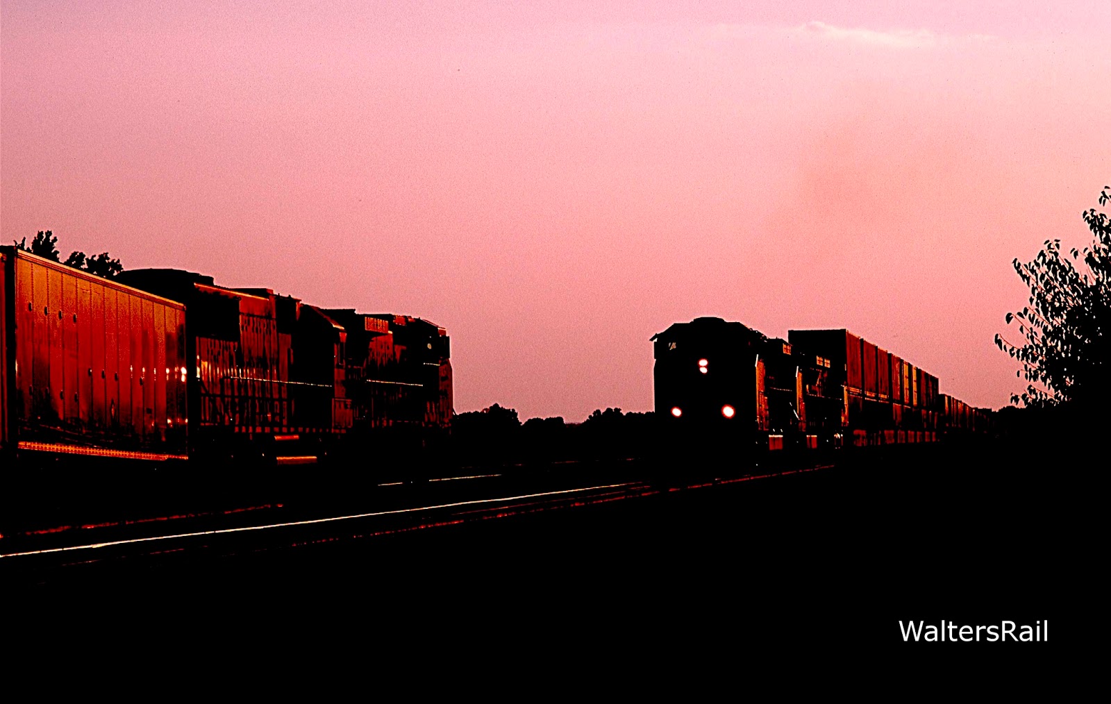
| An eastbound manifest is running on the triple-track mainline through Ellinor. |
Many a day after work, I would drive to Ellinor to watch and photograph the parade of BNSF intermodal traffic. I would arrive close to sundown, and I soon discovered that, because of the traffic frequency, and the east-west direction of the tracks, I would often see a train in the short time, about fifteen minutes, when the sun hangs orange-red on the horizon, then drops suddenly, darkening the landscape as though a curtain has been closed.
I began to seek such shots and offer the best in this post.
 |
| Eastbound stacks and trailers approach the west signal tower at Ellinor. |
West Signal Tower
One of the best locations for photography at Ellinor is the west signal tower. Many years ago, this area was guarded by old AT&SF target signals, all of which were replaced in the 21st century by two shiny new towers (east and west) that have become landmarks along old U.S. Highway 50, probably the least travelled transcontinental route across the United States. The road starts in Ocean City, Maryland, passes the White House in Washington, D.C., then crosses Virginia, Ohio, Indiana, Illinois, Missouri, Kansas, runs beside the Royal Gorge in Colorado and Placerville in California, eventually terminating at the Embarcadero in San Francisco.
If you drive the route from Maryland to California, you will recognize that you have entered the American West when you reach the Flint Hills at Ellinor -- because as you drive up out of the Cottonwood River valley, you will see mildly undulating grass-covered hills without a tree in sight. The grasslands stretch as far as the horizon. If you have never experienced this before, you will almost certainly feel disoriented, especially if you have lived your life in woodlands. You are now in a country of emptiness, nothingness, where the sky stretches from horizon to horizon, and you begin to grasp the smallness and insignificance of people and their worries.
"As to scenery (giving my own thought and feeling), while I know the standard claim is that Yosemite, Niagara Falls, the Upper Yellowstone, and the like afford the greatest natural shows, I am not so sure but the prairies and plains, while less stunning at first sight, last longer, fill the esthetic sense fuller, precede all the rest, and make North America's characteristic landscape." -- Walt Whitman.
Each evening the sun drops behind the hills west of Ellinor, and many evenings a BNSF freight will come blasting beneath the west signal tower either just before or just after the sun has gone. The following images were taken in that location and brief window of time.
 |
| The rear of an eastbound Q train is passing beneath the west signal tower at Ellinor. The east signal tower is visible in the distance. |
 |
| A westbound bare table rolls between the signal towers. |
 |
| BNSF 5714 West is photographed beneath the west signal tower after the sun has departed. |
 |
| After sunset, westbound stacks roar through Ellinor. |
 |
| BNSF in Spanish. |
The East Signal Tower
The East Signal Tower looks back toward Emporia, Kansas City and the great deciduous forests of the east. Unlike the surrounding Flint Hills, the valley of the Cottonwood River is heavily forested, and every ten years or so, the railroad must cut back the timber to keep it from encroaching on the right-of-way.
East of Ellinor, the triple-track mainline is divided. Two tracks run at ground level, while a third track to the south is built on a embankment about twelve feet tall. This unique arrangement was brought about by the Great Flood of 1951.
 |
| BNSF 7671 West, a taconite train, roars beneath the East Signal Tower. The middle of the same train is shown below. |

On July 8th and 9th, 1951, over nine inches of
rain fell, and the Cottonwood River rose more than ten feet in two days. The
headline on the July 11, 1951, issue of the Chase County Leader read, “Worst Flood In All History Hits Tuesday.”
The
newspaper reported that in Saffordville “buildings of every nature [were] deposited in the most
improbable places,” and that “buildings [were] lurching like drunken men
against each other.” Residents reported
water heights of up to 51 inches in their houses. Some had to climb onto roofs and wait to be
rescued by rowboats.
Eventually,
over a period of many years, almost every house in Saffordville was moved to higher ground. The houses were lifted off their foundations,
placed on wheels and rolled into the surrounding Flint Hills. Today, virtually every house in those hills
within ten miles was originally located in Saffordville.
 |
| Stacks are rolling between the signal towers as the sun prepares to emerge from behind low clouds. |
 |
| Pushers on a westbound grainer are approaching Ellinor from the east. |
 |
| Eastbound stacks coming off the LaJunta Subdivision are approaching the west signal tower at Ellinor. |
Along the
tracks stands an abandoned grain storage facility with a profanity scribbled
beneath the name of the grain company.
The depot, like the houses in the town, was moved offsite and used by a
local farmer as a storage building until burning to the ground in the
1990’s. Whenever I would stop my car to watch
trains, several apparently wild but friendly dogs would wander over and inspect me
and my vehicle.
As mentioned, the three-track BNSF mainline is notable because main three is built on a much higher grade, an acknowledgement by the Atchison, Topeka and Santa Fe that recurrent flooding required the significant raising of at least one line to keep trains moving.
As mentioned, the three-track BNSF mainline is notable because main three is built on a much higher grade, an acknowledgement by the Atchison, Topeka and Santa Fe that recurrent flooding required the significant raising of at least one line to keep trains moving.
From Saffordville to Ellinor, BNSF has recently removed telephone
poles, wires, brush and trees. Photographic
opportunities are now available that haven’t existed for many years and soon
will become overgrown. But right now,
the right-of-way from Saffordville to Ellinor is as open as the Kansas sky.
 |
| Eastbound stacks are coming off the La Junta Subdivision. |
 |
| Eastbound stacks and trailers on the La Junta Subdivision are passing westbound stacks on the Emporia Sub. |
Saffordville was founded in 1872 as Safford, shortly after
the Atchison, Topeka & Santa Fe built through the area. By the end of 1872, it had a post office, a
depot and a store, and by 1901 a creamery, hotel, and at least twenty houses. By 1887, mail was being sent to the town
addressed for Stafford, Kansas (northwest of Wichita), so in that year the
town's name was changed to Kenyon. Then,
mail began arriving addressed for Cañon City, Colorado, so in 1888, the name
was very briefly changed back to Safford before becoming Saffordville after a
group of railroad workers painted "Saffordville" on the train depot.
Palenske Ranch
The land surrounding Ellinor is part of the huge Palenske Ranch, which covers thousands of acres in the bottomland of the Cottonwood River. The ranch is so big that it operates two grain elevators to provide feed for the livestock. In high summer, when the sun sets well north of due west, the southernmost elevator makes a nice background for images of trains in the dusk. Occasionally, it is possible to photograph a train with both elevators.
 |
| Late of an overcast afternoon, another in the parade of eastbounders off the La Junta Subdivision approaches Ellinor, with the Palenske Ranch grain elevator in the background. |
 |
| An eastbound oil train is framed beneath the setting sun and beside the grain elevator. |
 |
| This image was taken shortly after a truck had driven past, raising dust in front of the eastbound train and the two grain elevators. |
 |
| Blackness prepares to descend across the Flint Hills. |
 |
| The sun descends beside the triple track mainline. |
 |
| Double and single stacks at dusk. |
The Parade of Westbounds
On Saturday afternoons, four to six westbounds may roll by
in 90 minutes or less. Slower movements
such as coal (bound for Oklahoma Gas and Electric’s Red Rock Generating Station
in Oklahoma) and grain are sometimes located in the middle of the fleet and
will pause at Ellinor while higher priority Z and Q trains run around on the
dash to Texas and California.
Because of
the high traffic frequency, a scanner is unnecessary for finding trains. Radio transmissions, however, are frequent –
most on AAR Channel 36. Trains waiting
at the junction will often call the dispatcher to determine the length of the
wait. Dispatching this section of the
BNSF must be among the most hectic jobs in the country, especially when
welders, signal maintainers and track inspectors are about. A train crew’s request for location of other
trains will often elicit a curt reply, such as, “Meeting three,” or “Have to
get back to you.”
Some of the
most entertaining radio traffic involves calls to “Forth Worth Mechanical,”
usually from a hotshot intermodal with a unit that isn’t loading. The exchange between crew and Forth Worth
almost always ends inconclusively, after various toggle switches are thrown and
computers re-booted, making you wonder if the train actually arrived anywhere.
 |
| Eastbound stacks are coming off the Emporia Subdivision. To the right, the La Junta Subdivision diverges westward to Colorado. |
 |
| Eastbound stacks and trailers meet a westbound RoadRailer. |
 |
| Eastbound stacks and trailers roll off the La Junta Subdivision. If you look closely to the left, you can see westbound stacks curving into the distance on the Emporia Subdivision. |
 |
| These stacks are rolling about halfway between Ellinor and Saffordville. |
The people here are some of the friendliest in the country. When they see that you are taking photographs,
some will stop to chat. Almost everyone
will have a story about the railroad, or Ellinor, or Saffordville or the many floods
through the years, and all will be proud that you think their home is
picturesque enough to photograph.
I leave you with four images that, for me at least, capture the heart of this place. If you've read this far, you will understand that no captions are necessary.


To see my other posts, go to waltersrail.com.
To see my photographs on Flickr, go to https://www.flickr.com/photos/jpwalters/.
No comments:
Post a Comment