 |
| A Union Pacific westbound merchandise freight is climbing the grade out of the Durkee Valley. |
Because the moon rotates at the same speed as the earth, we always see its same face. What we call the far side of the moon was completely unknown until the advent of space travel, when humans were first able to observe that back country. From an earthbound perspective, however, the moon is two different worlds -- seen and unseen, known and unknown, comprehensible and incomprehensible, inviting and uninviting.
The great state of Oregon is like the moon. Western Oregon is wet, verdant and enticing. Eastern Oregon is dry, brown and forbidding. Early European travelers along the Oregon Trail saw eastern Oregon as a barrier, not a destination, as they crossed the Snake River and began the long climb up the Burnt River Canyon to the Blue Mountains.
Contemporary Oregon maintains that split-personality. In the west, people are insanely liberal, while dwellers in the east are solitary and guarded -- a classic illustration of how personalities are shaped by geography. This point was driven home to your author while exploring Hell's Canyon along the Oregon-Idaho border.
Hell's Canyon is a little-known scenic wonder chiseled through towering granite mountains by the Snake River, which flows more than one mile below the canyon's west rim on the Oregon side and 7,400 feet below the peaks of Idaho's Seven Devils Mountains to the east. Unlike the Grand Canyon carved through the relatively flat Colorado Plateau, Hell's Canyon lies deep in a wonderland of pinnacles and is almost completely inaccessible. No major highway or railroad runs anywhere nearby, nor is the canyon on the way to anywhere. Your author reached it by driving east from Baker City, Oregon, across some of the most isolated and at the same time most beautiful state highways ever seen.
A narrow road climbs a mountain to a solitary canyon lookout. The contrast with the Grand Canyon could not be more extreme. Where the Arizona landmark contains a lodge, visitor's center, railroad depot and multiple trails, Hell's Canyon contains a small parking lot and smaller overlook where the forest has been cleared. That's it. The day I visited, only one other vehicle was in the lot, the transportation for two men as strikingly different as the two canyons. One man was almost seven feet tall; the other barely five. They appeared to be long-time travelers as comfortable with each other as brothers. The tall man talked constantly to his companion. The shorter man said nothing. I am not gregarious by nature and so left them alone.
I stood on the edge of the overlook, peering deep into the gorge that presented itself like an unexpected visitor, trying to imagine the millions of years required for the creation of such a marvel. The air was still, and I heard the sound of rushing water over a mile below.
On the way back to Baker City, I stopped deep in the forest at a solitary convenience store and gas station. After filling up my Jeep, I walked inside to purchase a snack and met a young man in his late thirties-early forties. (I am 72 as I write this, and early forties seem young.). He was short and wide like a piece of furniture, with dark hair and beard and two narrow eyes that looked at me with a mixture of curiosity and disdain, as though he were trying to decide if I were friend or foe. I naively assumed that all Oregonians were as politically liberal as those from Portland and was thus surprised when, after telling him I was from Oklahoma, he said: "Damn! I wish I could go back there."
He told me he had worked in the oil fields several years -- the "best years of his life," he said. But then he had moved to Oregon, and now he ran this isolated convenience store on the edge of Hell's Canyon and wished he could move back to the Sooner State. Later I discovered that several counties in eastern Oregon are trying to secede and become part of Idaho.
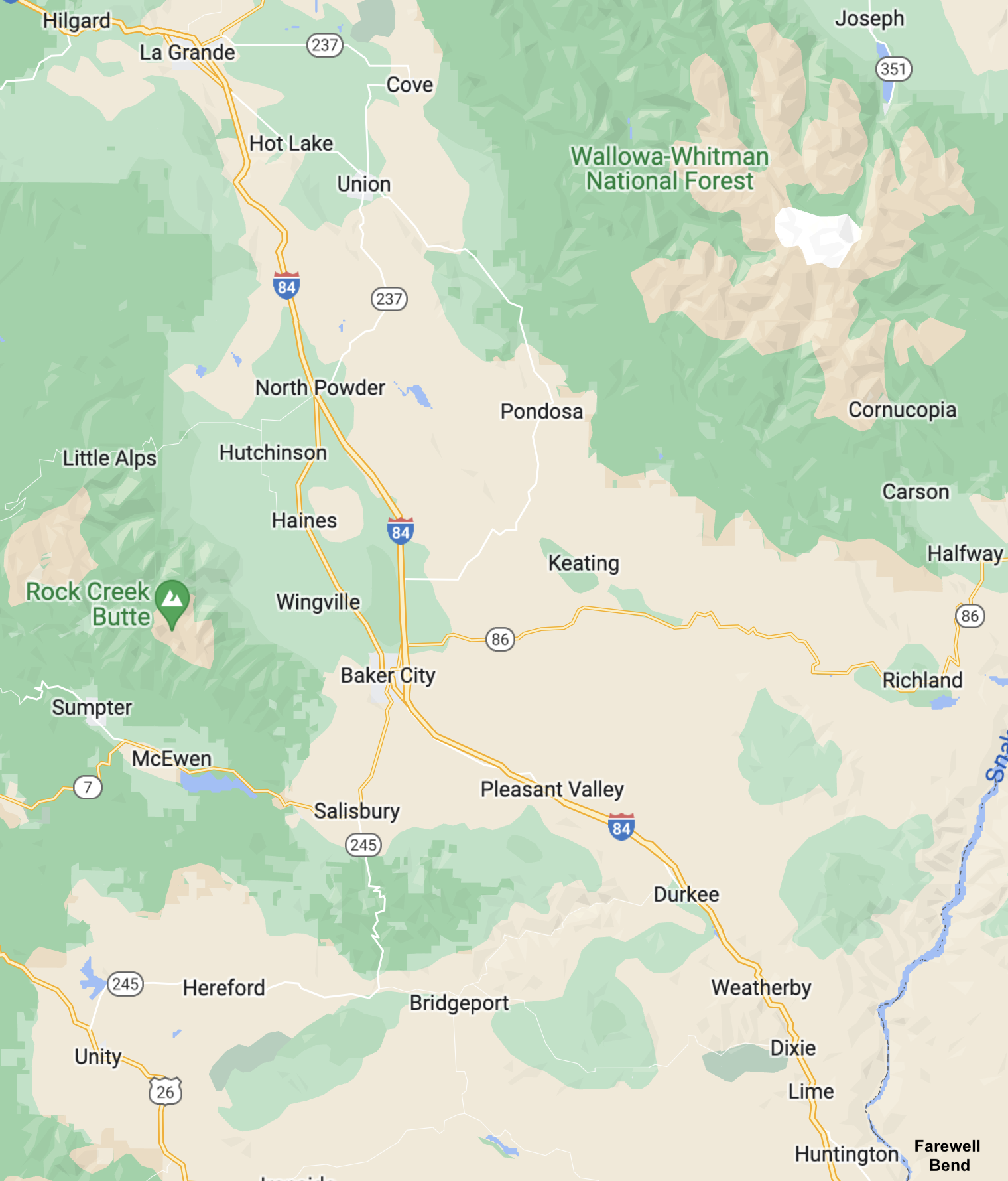
The images in this article begin at the confluence of the Burnt and Snake Rivers in far east central Oregon (called Farewell Bend) and follow the Union Pacific tracks (roughly along the route of Interstate 84) northwest to Durkee and on to Baker City, stopping at Hot Lake, a naturally-heated sulphur spring where people once congregated when they thought the waters could heal myriad ailments. Along the way, the railroad crosses two summits on this long approach to the Blue Mountains, which are not included in the coverage herein but which the author hopes to survey at some future date, age permitting.

The first official exploration of this country was conducted by Captain John Charles Fremont of the Corps of Topographical Engineers, whose expedition surveyed the area in 1843. Acting under orders from Colonel J.J. Abert, Fremont was participating in a War Department survey of the West in conjunction with coastal surveys carried out by the Navy. In the preceding year, he had explored the northern Rocky Mountains.
 |
| John Charles Fremont |
The adventures of men like Fremont convince me that I was born a century too late. Exploring mountains, canyons and rivers untouched by European civilization would have been the thrill of a lifetime, similar to space exploration in the modern era. Of course, the coming of Europeans spelled the end of the pristine wilderness and of the Native Americans, its stewards. So I guess that my dream, like everything else in life, contained both good and bad, up and down, ying and yang. Whether the good outweighed the bad depended, as they say, on whose ox was gored.
A Georgia native, Fremont led five expeditions into the western states. During the Mexican–American War, he was a major in the U.S. Army and took control of California from the California Republic in 1846. He was subsequently court-martialed and convicted of mutiny after a conflict over who was the rightful military governor of California. His sentence was commuted by President James K. Polk, but Fremont resigned from the Army and settled in California, where gold was found on his ranch. He was elected as one of the first two U.S. senators from the new state of California in 1850 and was the first Republican nominee for president of the U.S. in 1856 but lost the election to Democrat James Buchanan. For a much more thorough discussion of Fremont, see my article at http://www.waltersrail.com/2022/02/union-pacific-palisade-canyon.html.
Fremont prepared a report of his explorations, printed by the U.S. Senate, which carefully detailed his ascent of the canyon of the Burnt River:
Leaving entirely the Snake River, which is said henceforth to pursue its course through canyons, admist rocky and impracticable mountains, where there is no possibility of traveling with animals, we ascended a long and somewhat steep hill; and crossing the dividing ridge, came down in the valley of the Burnt River, which here looks like a hole among the hills. The average breadth of the stream here is 30 feet; it is well fringed with the usual small timber; and the soil in the bottoms is good, with better grass than we had lately been accustomed to see. [Fremont's report is available at https://archive.org/details/reportofexplorin00frem_1/page/n7/mode/2up.]
 |
| A Union Pacific freight has just crossed the Snake River and is climbing west through the canyon of the Burnt River. |
 |
| At dusk, eastbound stacks enter the small settlement of Huntington, the meeting point of the Oregon Railway and Navigation Company and the Oregon Short Line (discussed below). The town was named after J.B. and J.M. Huntington, brothers who purchased the location from a previous owner. |
Fremont's party then traveled through what he termed "very mountainous country," crossing and recrossing the river, which switch-backed east and west between canyon walls. Horses and oxen grew fatigued with the steep hillside climbs required to avoid narrow gorges unsuitable for the wagons. With few exceptions, the mountains were grass-covered, trees surmounting only some of the tallest peaks. When Fremont saw the country in mid-October, everything was dark green after rains, but the land turns golden brown in the summer much like the hills and peaks surrounding Tehachapi Loop.
 |
| Crossing the Burnt River in its narrow canyon, UP 7017 East is approaching Huntington. |
 |
| The Burnt River Canyon. |
European immigrants had preceded Fremont along what became known as the Oregon Trail, and others soon followed. In 1844, James Clyman joined a large party west and kept a diary of his adventures. Born in 1792 on a farm that belonged to George Washington in Fauquier County, Virginia (his parents owned a life tenancy on the land), Clyman received no formal education but did learn to read and also to write after a fashion. He migrated from place to place with his parents and siblings, moving from Virginia to Pennsylvania, and then to the Ohio frontier, settling in Stark County, Ohio, in 1811, where Clyman actively defended his family and friends from raids by Native Americans struggling valiantly but futilely to retain their property and way of life.
 |
| James Clyman |
He later traveled to the Rocky Mountains as a fur trapper and fought in the Black Hawk War. With the money he made in furs, he purchased land in Illinois to settle down and, he hoped, raise a family. But domestication was not his lot. He had spent his whole life on the edge of the frontier and even well beyond it, and as Illinois began to "settle up" into a civilized place, Clyman decided to move on. At age 52, advanced years in the 19th century, he joined a party west across the Oregon Trail to what everyone hoped was the Promised Land.
The lure of free real estate in Oregon and California (under Mexican jurisdiction at that time) tempted virtually every farmer from Tennessee to Missouri, plus points north and south -- a new type of pioneer, not hermits fleeing civilization nor mountain men wanting to go where no one had gone before (if you didn't count Natives), but whole families who piled all earthly possessions into covered wagons pulled by oxen, traveling across a continent that neither they nor their guides really understood, a continent that west of Missouri contained few roads, just wagon ruts, a continent that would not be properly mapped until their entire generation had passed.
About 1500 people started West in 1844, to that time the largest group ever in a single year, five parties in all, three traveling to Oregon under the leadership of Cornelius Gilliam, John Thorp and Nathaniel Ford. Clyman joined Ford's group of about 500 at Independence, Missouri.
His diary is filled with the idiosyncratic spelling, capitalization and punctuation (mostly lack of periods) common before universal public education and describes the confluence of the Snake and Burnt Rivers (called Farewell Bend) and the canyon to the northwest:
Clear as usual for it has not rained Since we left Fort Larrimie passed a ridge & soon Struck by what we Supposed to be Burnt River Quite a small criek Bound in by steep high Lime rock Mountains almost impossible for our horses yet the wagons have gone this rout these mountains as well as those passed yesterday shew all the visible effects of fire . . . Made 17 miles through the worst mountains and over the worse road we have yet seen the sides of these mountains are nearly pependicular and composed of granite & rough Slate rock without any timber or any other kind of vegitation except Short grass and in many places entirely bare. [Clyman's diary is available at https://archive.org/details/journalofmountai0000clym]
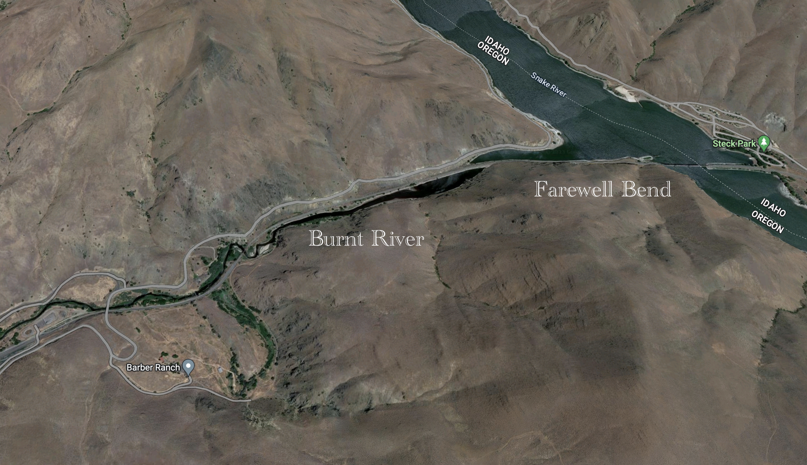 |
| Farewell Bend is where the the Oregon Trail left the Snake River. North of this location is Hell's Canyon, impassible to this day by anything on wheels. Union Pacific's bridge across the Snake River is visible in the upper right. The tracks run along the south bank to Huntington, where they and the river turn north. |
In 1846, Congress authorized a line of military posts along the Oregon Trail and created a mounted rifle regiment to construct and garrison them. Those plans were interrupted for two years by the Mexican-American War, which among other things ceded California to the United States by the Treaty of Guadalupe Hidalgo, but by 1849 the regiment was prepared for its original assignment and departed Fort Leavenworth, Kansas, on May 10 -- the first military unit to travel the entire length of the Oregon Trail, with seven hundred horses and twelve hundred mules. The entire party was stretched across the High Plains like a gigantic rubber band about to break, but heat and lack of water soon began to cull the herd, and by the time the regiment reached the Snake River, numbers had been reduced by almost half.
Major Osborne Cross, the quartermaster, prepared a journal of the expedition and noted that the trail was crowded with gold seekers, all of whom turned southwest at the Raft River to take the California Trail. To the northwest, the Oregon Trail was mostly deserted. The regiment arrived at Farewell Bend September 3.
[The Burnt River] turning to the northeast breaks through the same range of hills, leaves a deep canyon in its passage, and falls into the Snake river not far from where we left it. These openings in the mountains hills are very striking and worthy the notice of those who travel this way. . . . We were completely hemmed in by the mountain hills that form a ravine through which this little stream passes.
[I have been unable to find Cross's journal on line. Several printed volumes are available for sale on the internet. My own source has been John W. Evans, Powerful Rockey: The Blue Mountains and the Oregon Trail, Eastern Oregon State College (1991).]
 |
| Major Osborne Cross |
The Burnt River Canyon is narrow and twisting like a rivulet, its walls almost perpendicular. As one moves northwest, the cliffs draw closer and closer like the swinging shut of an electric gate, and the feeling of claustrophobia grows, even for those with no concern for small spaces. Constructing a railroad through this confine was no mean feat, to say nothing of the building of Interstate 84 almost 100 years later. Pulling loaded wagons through the rocks, where barely a road existed, seems out of the question, at least to this author.
Major Cross wrote:
We commenced the march at half-past six o'clock this morning up the ravine, which became so narrow that the road passed along the bed of the river for some distance. It again turned to the right and winding around the base of the hills through a very narrow gorge brought us once more on level ground, where the face of the country was entirely changed. Mountains were to be seen all around and it appeared a mystery how we had extricated ourselves from those left behind . . . or how we were to pass those ahead of us.
 |
| Aerial view of a portion of the Burnt River Canyon. Interstate 84 dominates the landscape today. The Union Pacific tracks are west of the highway and duck through a ridge in a short tunnel. Some travelers on the Oregon Trail would have climbed the hill above where the tunnel was bored. Others would have followed the river north through a narrow horseshoe. |
 |
| Interstate 84 and the UP make the narrowest sections of the Burnt River Canyon look passible, but that is because of the enormous excavation involved in their construction. Imagine trying to navigate a covered wagon through this location in its natural state. |
 |
| Deep in the Burnt River Canyon, UP 2704 West leads a merchandise freight upgrade. |
Upstream, past the narrow canyon, the Burnt River opens to the Durkee Valley -- which Major Cross described immediately above. To the east stand the Lookout Mountains; to the south the Pedro Mountains. To the north is the saddle between the Burnt and Powder River drainages. The Union Pacific laid its tracks directly through the heart of this valley, following the paths of Fremont, Clyman and Cross. The Oregon Trail climbed the saddle in a torturous ascent.
 |
| From the south, the Durkee Valley forms an upside-down "T" and marks the dividing line between the watersheds of the Burnt and Powder Rivers. Interstate 84 blasts directly up the dividing ridge on a grade too steep for the Union Pacific, which softens the climb at the Pritchard Creek Horseshoe. The climb up this ridge was very difficult for the animals and immigrants. |
 |
| An eastbound manifest descending through the Durkee Valley. |
 |
| This westbound is climbing toward the Pritchard Creek horseshoe. In the background stands the Durkee Community Church. |
 |
| UP 3003 West leads its train past the west end of Durkee Siding. |
The following images were all taken at the Pritchard Creek horseshoe, in your author's estimation one of the most spectacular railfan locations in North American. The country is open and mostly deserted. A very few farm houses dot the landscape, and cattle here and there graze aimlessly through irrigated pastures. A primitive county road climbs the hills to the east of the tracks and will lead you, if your vehicle is rugged enough, to one of the most bucolic locations one can image for watching trains.
 |
| The southeast edge of the horseshoe begins a double track section to the top of the hill. Westbound stacks have stopped on Main One just short of where the steep grade begins to exchange crews with an approaching eastbound. |
 |
| An eastbound manifest is coming downgrade to meet the stacks. The second unit looks as though it recently caught fire. |
 |
| Eastbound in the horseshoe. |
 |
| A meeting in the Durkee Valley. |
 |
| Iron Mountain Road, a public thoroughfare, climbs the hills east of the horseshoe. The arrow points to the prime location for photographing the Union Pacific. The images below we are all taken from that spot. |
 |
| In full dynamics, an eastbound manifest approaches the horseshoe. |
 |
| Same train filling the horseshoe. |
 |
| Westbound grain. |
 |
| Westbound stacks. |
 |
| Same train. |
 |
| Same. |
On the west side of the horseshoe, the tracks run through a deep cut, then onto a fill, then begin a long upgrade curve as they climb the ridge to the Powder River drainage basin. Access here is possible, though not easy, but worth the effort.
 |
| The west side of the horseshoe. |
 |
| Stacks headed northwest to the Columbia River. |
After leaving the horseshoe, trains struggle for several miles into the grade. Even traffic on the interstate slows, heavy trucks creeping like beetles. In this location, guides, immigrants and oxen must have wondered if they had made a mistake in vacating the verdant flatlands.
 |
| This brutally long manifest is crawling at less than five mph. A small dog could climb the hill faster. |
 |
| The line here is double track. |
 |
| Crawling westward. |
 |
| Still climbing. |
 |
| At this location on the hill, even this Z train has slowed to a crawl. |
 |
| Downgrade. |
 |
| At the summit. |
At the top of the grade, because of the lack of trees, one can see across the country for miles in all directions, with the blue sky overhead like the lid of a gigantic pot. To the north, the mountains are now heavily forested. Major Cross described them:
After passing this morning through the valley in which we encamped last evening the road brought us to the top of a high ridge, giving us a beautiful view of the mountains running east and west and parallel to the ridge over which we were passing. The sight was very fine, as these mountains were the first we had seen covered with pine.
Coming down, one enters the valley of the Powder River, several magnitudes larger than the Durkee Valley, as though when He created the earth, God said, "This will be a good place for people to settle." Mountains to the west rise almost vertically from the ground like a snow fence. The river is narrow and shallow and runs with cool clear mountain water.
Cross said:
This valley has many advantages over those I have passed on the march besides having a fine stream running through it. The mountains in the vicinity are covered with pine and hemlock, which is easy to procure. The soil is light and sufficiently level to be irrigated and will no doubt yield well when properly cultivated.
 |
| Powder River Valley. The prominent circles are irrigated farmland. |
 |
| This eastbound manifest is climbing out of the Powder River Valley. In the background are the forested mountains described by Major Cross. |
 |
| Another eastbound climbing the grade. |
 |
| Eastbound approaching the summit. |
The American West is set apart from the East by a constant that Major Cross was fortunate not to encounter -- fire. Clyman saw it firsthand.
The day very Smoky & I Begin to daubt Mr. Espys theory of produceeing rain by any phisical means as the whole country has been on fire for a month past & no rain yet a range of mountains lying close to our left seem to be all enveloped in Smoke
Because we think that we, our time and our place are all unique, we believe that our troubles and problems are the worst ever experienced. Thus, we think that Western forest fires are a plague never before seen on the planet, at least not in the intensity experienced today. Clyman's diary gives the lie to this parochial thought, and does Norman McClean's marvelous book Young Men and Fire, a lyrical discussion of the 1949 Mann Gulch Fire in Montana that killed 13 "smoke jumpers," young men who parachuted into remote country, intending to stop fires before they exploded into disasters. But the Mann Gulch Fire exploded too fast, and many perished.
McClean describes the process by which a seemingly innocuous blaze becomes a killer:
A fire doesn't always need flames to advance. A fire may seem under control, burning harmlessly under tall trees with branches too high to be touched by ground flames, but the fire is burning with such intensity that most of the oxygen has been burned out of the air near it, which is heated above the point of ignition. If the wind suddenly changes and fresh air is blown in loaded with oxygen, then the three elements necessary for a fire are suddenly present in the lower branches -- flammable material, temperature above the point of ignition, and oxygen. An old-timer knows that, when a ground fire explodes into a crown fire with nothing he can see to cause it, he has not witnessed spontaneous combustion but the outer appearance of the invisible pressure of a "fire triangle" suddenly in proper proportions for an explosion. Norman McClean, Young Men and Fire, University of Chicago Press, p. 35 (1992).
Western forest fires have consumed North American far longer than people have lived on this continent and will continue to burn long after the last man and woman are gone. The fires witnessed by Clyman did no lasting harm to the mountains surrounding the valley of the Powder River. When your author visited in the summer of 2022, over 180 years later, those steep, almost vertical slopes were verdant with pine and western larch, though it had not rained for over 90 days and would not rain until well into fall.
Native Americans saw fire as their ally, not their enemy. They periodically burned grasslands to keep them clear for game and also used blazes to defend against immigrant invaders. Clyman said:
As we caught our horses for our afternoons travel Some Indian as is their habit when they discover Strangers in their country set fire to the grass about a half mile ahiad of us our route being N. & a strong south wind blowing the fire kept ahead of us through the hills about 6 or 8 miles and when we overtook the fire we had some difficulty in passing it but all got through nearly suffocated . . . the whole mountains which surround this valley completely enveloped in fire and Smoke
Today the town of Baker City sits in the Powder River Valley, a former mining community that has reinvented itself as an agricultural crossroads, fulfilling the prophecy of Major Cross. Though the surrounding mountains are heavily forested, the valley itself averages barely more than 10 inches of rain per year, which effectively makes it a wet desert. About 50 years ago, however, a solitary land owner decided to dig a deep well mostly to see what was down there and discovered, to his surprise, a vast reservoir of underground water. He began irrigating his land, and the rich soil quickly produced bumper crops of red wheat. Potatoes, mint and sugar beets quickly followed. Irrigation also produced hay that today feeds a major cattle industry.
I met the landowner's son one afternoon while waiting along an isolated dirt road for a train, and he told me how his father had drilled the well and become the first farmer in the valley. With the money gained from his efforts, the father began buying land that others thought was mostly worthless and soon owned thousands of acres, which today the son farms with obvious pride. He and I chatted for almost an hour as two Union Pacific freights roared past and I explained to him what I knew about the construction of the railroad. When we parted, he gave me the name of a local steak house, which that evening prepared for me an excellent meal.
The Powder River Valley stretches about fifteen miles south to north and about five mile east to west. Bounded on the west by the Little Alps and on the east by the Wallowa-Whitman National Forest, this basin provided a respite for travelers along the Oregon Trail coming north from Farewell Bend and the rugged Burnt River Canyon. Here the immigrant parties could stop for several days, allowing their animals to graze, while also replenishing their strength and courage, for the trip ahead across the Blue Mountains was even more challenging, not for the faint of heart, especially for those making the journey late in the year, which for this country can be the last half of October when snows begin at highest elevations.
Major Cross found the valley congenial:
We remained here tonight, having fine water, plenty of wood for ourselves, and good grazing for our mules and horses. This stream [Powder River] is about thirty feet wide, is clear, and runs quietly over a gravelly bottom. Here brook trout and salmon are found in great numbers.
Clyman said:
Passed through a beautifull vally this fore noon well grassed but to dry for cultivation a Timbred mountain close to our left the same seen range yestarday morning.
And Fremont:
We travelled this morning across the affluents to Powder river, the road being good, firm, and level; and the country became constantly more pleasant and interesting. The soil appeared to be very deep, and is black and extremely good, as well among the hollows of the hills on the elevated plats, as on the river bottoms; the vegetation being such as is usually found in good ground.
 |
| An eastbound manifest in the Powder River Valley is passing a field of sugar beets and the industrial sprinkler that irrigates it. |
 |
| Westbound stacks in the Powder River Valley. |
 |
| Eastbound approaching Baker City. |
There is no easy exit from the Powder River Valley, which is like a flat-bottomed bowl in a sand box, surrounded by mountains and hills that prevent tranquil passage. In the 20th century, Interstate 84 climbed the grade to the north through territory much too rugged for covered wagons and later railroads. The Oregon Trail serpentined to the east through a narrow defile in the hills and climbed the second sustained grade between Farewell Bend and the Blue Mountains, the route later followed by the Union Pacific. Today a narrow country road mostly follows the tracks through a cleft barely wide enough for automobiles. Trains struggle in both directions to reach the summit at Telocaset, a Nez Perce word meaning "a thing at the top" or "put on top".
 |
| Telocaset, Oregon. |
As you travel north past the summit and down the mountainside, the Grande Ronde Valley comes into view, a magnificent spectacle like a banquet table in a palace. Where the Powder River Valley is almost cozy, the Grande Ronde Valley is spacious and luxuriant. Another metaphor comes quickly to mind: Los Pastos Del Cielo (The Pastures of Heaven).
Here is Fremont's description:
About two in the afternoon we reached a high point of the dividing ridge, from which we obtained a good view of the Grande Rond -- a beautiful level basin, or mountain valley, covered with good grass, on a rich soil, abundantly watered, and surrounded by high and well-timbered mountains; and its name descriptive of its form -- the great circle.
The Grande Ronde Valley floor is at about 2,700 feet above sea level, and its horizon is dominated by the Blue Mountains. Standing in the valley is like standing on an airport tarmac surrounded by jumbo jets. The highest nearby peaks are Mount Fanny to the east, elevation 7,136 feet; Mount Harris to the northeast, 5,335 feet; and Mount Emily to the northwest, 6,110 feet. Communities include Cove, Imbler, Island City, La Grande, Summerville, and Union, of which only La Grande is of any noticeable size, though all are beautifully located. LeGrande contains a Union Pacific yard and facilities, plus Eastern Oregon University, one of the most bucolic small campuses your author has ever seen.
When Major Cross first saw the valley, he realized that a railroad could not be far behind:
The only objection, therefore, which can be made to this section of the country is the great difficulty in getting produce to the Columbia river. This could be easily remedied, and the day is not far distant, no doubt, when a railroad will overcome these objections. The distance between here and the Dalles is about two hundred five miles, as the road now runs, passing through the Umatilla valley, which would avoid the high hills and present not the least obstruction. There is timber enough to be found here at and at the Dalles to build a railroad to the Atlantic ocean.
The railroad (Oregon Railroad and Navigation Company) came through in 1884, the product of Henry Villard's desire to keep the Union Pacific out of the Pacific Northwest. Villard built a transportation empire in Washington and Oregon, lost it, regained it, then finally lost it for the last time. His story almost defies belief, is told in detail in https://www.waltersrail.com/2023/04/powder-river-basin-part-two-union.html and need not be repeated here.
The railroad was basically constructed by hand, mostly Oriental hands supplied by Chinese-owned companies operating out of San Francisco. With picks, shovels, wheelbarrows, horses and two-wheel dump carts, those men constructed mile after mile through some of the most rugged terrain in the West.
While Villard was building East, the Union Pacific was building west and had reached Shoshone in Idaho. The two companies now raced toward each other much as had the Central Pacific and Union Pacific in Utah. The OR&N sent surveyors as far south as Farewell Bend and then began dirt work in that area to forestall Union Pacific incursion. Eventually the railroads agreed to connect at Huntington, Oregon, on the Burnt River, just slightly upstream from its confluence with the Snake. The Huntington extension reached Meacham, about twenty-five miles northwest of La Grande, on October 3, 1883. After borrowing another $6 million, the OR&N reached Huntington on November 25, 1884. Through service to Omaha commenced December 1.
The OR&N operated 1,143 miles running east from Portland to northeastern Oregon, northeastern Washington, and northern Idaho. Once Villard was out of the picture, the railroad became easy pickings. The UP purchased a majority stake in 1898, the line became a subsidiary of UP (the Oregon–Washington Railroad and Navigation Company) in 1910, and in 1936, the Union Pacific formally absorbed the system, UP's gateway to the Pacific Northwest.
The railroad generally followed the Oregon Trail except where the grade was too steep, for example, the Pritchard Creek horseshoe. Also, the railroad diverged from the trail at the Grande Ronde Valley to the summit at Telocaset.
The first construction surveys for crossing that valley called for the line to stay north of Island City, then swing wide to the east around the tule marsh near Hot Lake, then through Union and up the east side of Pyle Canyon. Another proposed route would have run the line to the west by way of Ladd Canyon, but it was ultimately found not feasible because the crossing of the east fork of Ladd Creek would have required a bridge taller than could have been constructed in the late 19th century. In the 20th century, this route was taken by Interstate 84, which saves about eight miles over that ultimately chosen by the railroad, which winds north from Telocaset along Pyles Creek through the west side of the very narrow eponymous canyon but does not enter Union. Instead, the tracks hug the side of the mountain, then upon reaching the valley floor at Hot Lake, run straight to the northwest to LeGrande.
 |
| The Grande Ronde Valley. Telocaset is the summit of the climb out of the Powder River Valley. The tracks wind down the mountainside to Hot Lake, where this survey ends. |
 |
| This westbound manifest has crested the summit at Telocaset and is rolling downgrade on the west side of Pyles Canyon on the approach to the Grande Ronde Valley. |
 |
| This eastbound manifest is climbing out of the Grande Ronde Valley. |
 |
| The two trains meet in Pyles Canyon. |
Hot Lake is aptly named, with water temperatures between 180 and 200 degrees Farenheight. Signs are posted around its eight acres, warning the unwary to avoid scalding themselves. The water emerges from deep thermal vents at an average of three million gallons every 24 hours. During the migrations on the Oregon Trail, it became a natural resting spot.
The only 19th century description I have found comes from the journal of Robert Stuart, which records an 1812-1813 trip from Astoria, Oregon, through St. Louis to Green River, Kentucky. Stuart left Scotland at the age of 22 and was employed by the North West Fur Company and later became a partner of John Jacob Astor. He sailed from New York for the Columbia River in 1810 and traveled back eastward in 1812-1813. His journal was published in 1935 as The Discovery of the Oregon Trail, Robert Stuart’s Narratives of His Overland Trip Eastward from Astoria 1812-1813.
Stuart vividly describes the location, calling it a sulphur lake 300 yards in circumference fed by a boiling spring that produced a very strong odor. He noted that the lake was frequented by elk to shed their antlers and commented on the extreme heat of the waters, which he believed were not much good for anything. But others disagreed, believing that hot sulphur waters could cure ailments as diverse as gout and tuberculosis. Some even thought the waters could heal polio.
A hotel was constructed on the property in the late 19th century. By 1908, the structure contained 108 rooms and was a popular resort. Called the "Mayo Clinic of the West," the property more or less died with its owner in 1931. Three years later, fire destroyed several structures and a portion of the hotel.
The grounds then sat unused for over 70 years. Today (May 2023) a restoration process is underway, and visitors can stay at the hotel, which looks, to your author, at least, like a once beautiful woman who has undergone too many face-lifts. The inside is dark and quiet and musty. When your author stopped there one afternoon, a few guests were sitting in the foyer, not talking, just sitting there like statutes. A young woman at the check-in desk told me that rooms were available. I said I was just passing through. The hotel was huge, with a ballroom big enough to hold several hundred people and a bar-lounge of equal size. Many had once stayed there, and I could feel their presence, as though past and future were melded in a single moment. But the general aura was decline, a slow slide temporarily impeded, though not arrested, by noble efforts.
Union Pacific's tracks pass within one hundred yards, but the small station was demolished years ago, as was the equally small post office.
 |
| Westbound stacks cross the Grande Ronde Valley. Hot Lake is directly behind the photographer. Ahead lie LeGrande, Oregon, and the Blue Mountains. Travelers on the Oregon Trail who made it this far could rest and hope that the route ahead would be forgiving. |
To see my other posts, go to waltersrail.com.
To see my photographs on Flickr, go to https://www.flickr.com/photos/jpwalters/.
No comments:
Post a Comment