
Not that long ago (early 21st century), as many as 100 or more coal trains per day ran into and out of the Powder River Basin. You could plant yourself anywhere along the tracks from Shawnee Junction to Donkey Creek and, during a busy hour, see 8-10 trains. In a “slow” hour, you might see three.
The intelligentsia in the United States have, however, declared war on coal, with the stated intent of closing all coal-fired generating plants. (The same war has been declared on oil and natural gas.) When I listen to them talk about the need to abolish carbon dioxide, which all plants require to survive, I despair. "Eliminate your carbon footprint," they say. However, since all of us exhale carbon dioxide with each breath, the only way to eliminate our carbon footprint is to die.
Recently, I began wondering what effect the war on coal was having on railroad traffic in the Powder River Basin, so in late September 2021, your author spent three weeks in and around Gillette, Wyoming, observing the situation for himself. What follows is the first of a two-part discussion of the Powder River Basin under assault. Part One covers BNSF. Part Two will discuss Union Pacific.
(I am not the best at identifying places. I've tried to locate various coal mines and roads, but there is a real possibility that I have made mistakes. In fact, if I have not made mistakes, it will be a first. If you see one [a mistake], point it out in the comments. Then breathe deeply. Let it go. You'll survive.)
 |
| https://www.researchgate.net/figure/Generalized-Geologic-map-of-the-Powder-River-Basin-and-surrounding-areas-Orange_fig1_335201750. |
As used in this article, “Powder River Basin” refers to the valleys and flatlands extending west to east from the Bighorn Mountains in north central Wyoming to the Black Hills on the Wyoming/South Dakota border, and includes the watersheds of the Powder, Tongue and Little Missouri Rivers. To one who has not lived in this land, such as your author, one who has not absorbed the fantastically varied weather and geography, the single most distinguishing characteristic of this place is the endless horizon, the line of infinity where land meets sky. In the Powder River Basin the horizon is as overwhelming as the universe itself – and as unknowable. Chasing the horizon in Wyoming is like chasing a mirage; the faster you run, the faster it recedes.
Wyoming’s horizon is so striking because you can see it, which is not as ridiculous as it sounds. You cannot see the horizon in a forest, nor in a cleared field surrounded by trees, nor in a city. There are very few places east of the Mississippi River where one can glimpse even a portion of the horizon. On the open sea, the horizon stretches beyond the limits of imagination; the same is true in the Power River Basin, where trees (mostly cottonwoods) are found only in river and creek bottoms, plus a few scraggly mountain cedars on the uplifts. But the open range is clear of obstacles, like the runway of an Air Force Base. Look in any direction, and the grasslands extend to meet the sky at the point where the earth curves beyond sight. To see this for the first time is to glimpse the overwhelming vastness that to Westerners is an afterthought, like the wind.
 |
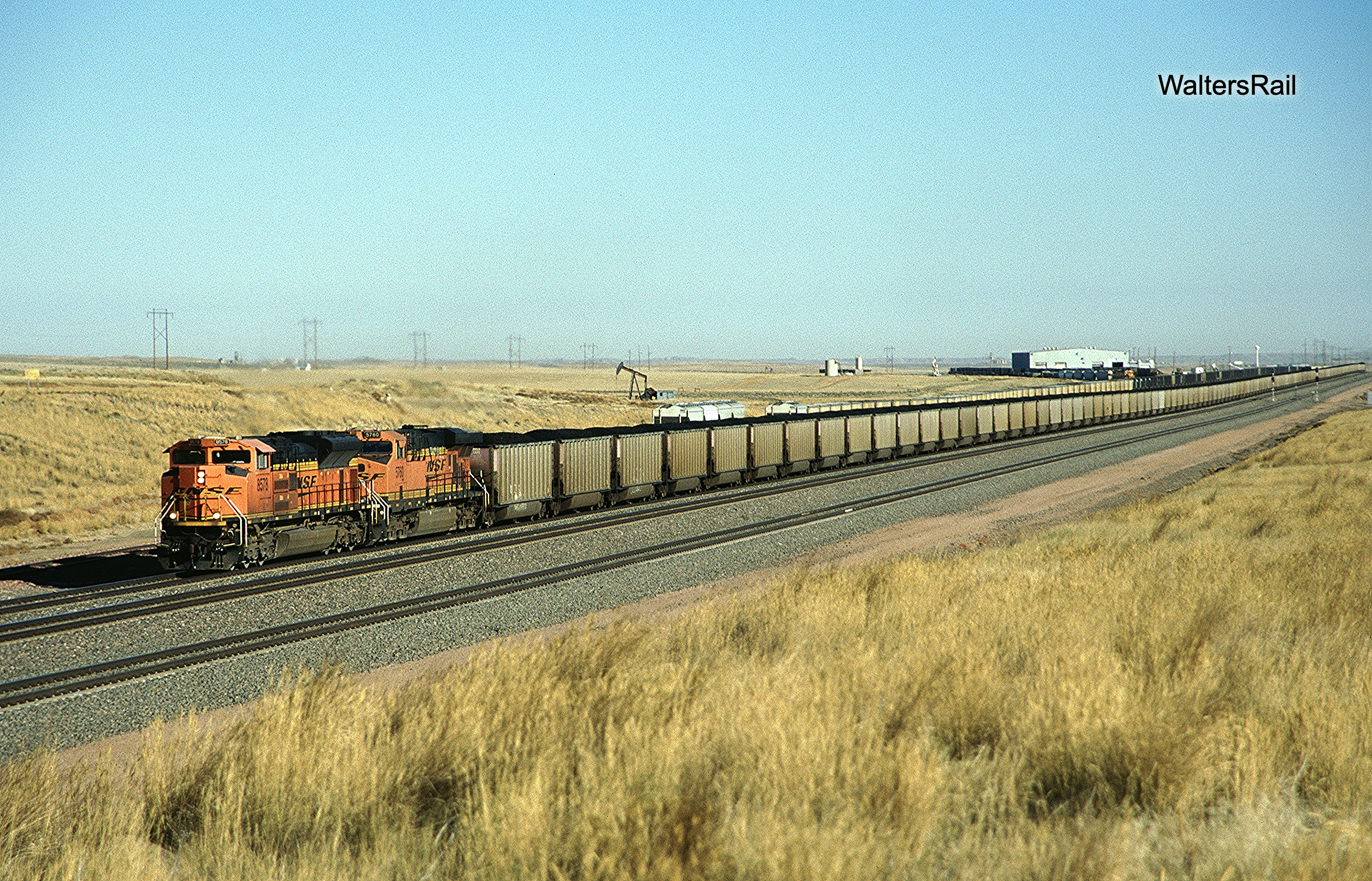
| A loaded BNSF coal train rolls south beneath the endless horizon. |
My first trip to Wyoming was in 1970, and my most vivid memory is feeling that I was standing on the very top of the world. Wyoming is the summit of a five-layer wedding cake, the dome of St. Peter’s, the flag flying from the world’s tallest flagpole. Other states have taller mountains – California and Colorado, for example – but none has taller valleys. My favorite illustration is the University of Wyoming, which sits in Laramie in a bucolic valley between tranquil mountains at 7,165 feet. For comparison, the tallest passes on the Canadian Pacific are Kicking Horse (5338 feet) and Rogers (4364 feet). The highest mountain east of the Mississippi is Mount Mitchell in North Carolina – 6684 feet. Sitting in a quiet valley, the University of Wyoming tops them all.
 |
| William F. Raynolds |
In the early 19th century, this country was unknown to those living east of the Mississippi River, a complete mystery. Some thought that a river flowed from the Great Plains to the Pacific Ocean. Others thought that the mountains of the northwest were impenetrable and therefore uninhabitable. Still others thought that the mountains sheltered broad fertile valleys that never froze – bathed in perpetual summer. The expedition of Lewis and Clark shattered those imaginary stained-glass windows but bypassed the Powder River Basin, exploration of which was carried out by Captain William F. Raynolds of the Army Corps of Topographical Engineers.
Raynolds was born March 17, 1820, the fourth of six children. His grandfather (also named William Raynolds) was a veteran of the War of 1812 in which he rose to the rank of captain. The younger Raynolds was graduated from West Point in 1843 in a class of 40, which included Ulysses S. Grant. Initially appointed a second lieutenant in the 5th U.S. Infantry, Raynolds was soon transferred to the Army Corps of Topographical Engineers, which conducted surveys and drafted maps until merger with the Corps of Engineers in 1863. Raynolds’ initial assignment involved navigational surveys of the Ohio River.
Raynolds served in the Mexican-American War under Winfield Scott. After cessation of hostilities, while the Army occupied Mexico City, he explored the surrounding mountains and was the first to reach the summit of Pico de Orizaba, at 18,620 feet an active strato-volcano and the third highest peak in North America, behind Denali in Alaska and Logan in Canada. Informed by locals that the mountain could not be climbed, Raynolds set out to prove them wrong.
A pack train of mules, officers, enlisted men and native guides departed Orizaba in May 1848. The tropical jungle presented obstacles never before encountered by those soldiers, mile upon mile of vegetation as thick as a hedge row, vegetation so thick and moist that it seemed to grow larger before their eyes, and more than once they thought of abandoning the project and returning to the comforts of Mexico City. But they pressed forward, eventually establishing a base camp at 12,000 feet, within a thousand feet of the timberline, and on May 10 attempted a final assault on the summit. Raynolds reached the snow-covered top and estimated the volcano’s crater at 400-650 yards in diameter and 300 feet deep. Three years later, a French expedition discovered an American flag at the summit with “1848” carved into its pole.
 |
| Pico de Orizaba |
In 1859, Raynolds was assigned by Congress to explore Montana and Wyoming, especially the Yellowstone and Cheyenne Rivers. The expedition included geologist F.V. Hayden, photographer James D. Hutton and mapmaker Anton Schönborn. Second in command was Lieutenant Henry E. Maynadier, supported by an infantry detachment of 30 men. Famed explorer Jim Bridger was the guide.
Raynolds prepared a report to Congress, which can be found at:
https://archive.org/details/reportofexplorat00rayn/page/n9/mode/2up.
To put it mildly, Raynolds was not impressed with the Powder River Basin. He was experiencing the West for the first time, unable to appreciate that which he could not comprehend, like a man awakening to discover that he is staring not at the nearby wall of his bedroom but instead into the infinity of a universe that he prefers to avoid: “The country traversed today is the same barren desert that we have been in since leaving the Platte — very little grass, no wood, and scarcely any water. I cannot conceive how it will ever be made inhabitable for the white man.”
 |
| "The same barren desert we have been in since leaving the Platte." |
His Summary Report to Congress contained the following descriptions of the rivers in the Powder River Basin:
Powder River: “Its valley (which is barren and yields but little grass and an abundance of artemisia) averages a mile in width throughout its entire length, until within 50 miles from its mouth, it becomes narrower and the bluffs more ragged and broken. . . . The bluffs bordering the valley are throughout the much-dreaded and barren ‘bad lands,’ and this stream must ever remain of little or no value to the country.”
Tongue River: “[T]he Tongue River valley presents few attractions to the settler. The soil is light, and the timber chiefly cottonwood, and scarce — disadvantages that will for years seriously affect its prospects for settlement and development.”
Little Missouri River: “The Little Missouri rises in the Black Hills, whence it receives a constant and considerable supply of water, and its length is over 200 miles. This stream having more timber upon its banks than its neighbors, is called by the Indians ‘Ohan-cho-ka,’ or Thick Timbered River. The title, however, is only comparative, and should not create the impression that the valley would be elsewhere considered heavily timbered."
For those raised in the wet East, the western United States upon first contact seems a desert wasteland devoid of life. This perception is the same as that of a man who has walked outdoors from a room crowded with music and dancing into the relative calm of an adjacent parking lot. At first the world seems to have disappeared, without sound or substance, as though one is floating weightless in the void. But if one has enough patience to stand quietly and listen, sounds begin to appear, random insects, the soft southern breeze, the wail of a lone coyote. But patience is necessary, and Raynold’s report to Congress is devoid of that moderating virtue. Everything is barren, lifeless, horrible, unlivable. His favorite phrase is “unfit for a white man,” or a variant.
The landscape before us was wide in extent, but characterized by forbidding desolation. The valleys of the Powder and its branch were marked by narrow and sinuous belts of green, but these, with here and there a solitary pine of stunted growth, constituted all the verdure that relieved the monotony of barrenness. Naked brown hills rose up on all sides, broken into irregular peaks, and with their sides torn in to deep and impassable gullies by the mountain torrents — a petrified representation of an angry sea in all the fury of a storm.
 |
| "The monotony of barrenness." |
Raynolds was astounded by the lack of trees, a deficiency which seems like a typographical error or an optical illusion to one who has lived his whole life in the forest. Why would trees suddenly stop growing? At the time of this exploration, the mid-19th century, many people believed that there were no trees in Western flatlands because of annual range fires that killed everything but grass. If the fires were stopped, the theory posited, trees would begin to grow, and more rain would fall. In other words, vegetation causes rain. This was a corollary to the belief that lack of rain was caused by lack of people. “Rain follows the plow!” was the battle cry. Settlers carried this belief into the West with predictable results. Dry land farms in Wyoming and Montana perished almost overnight. In the early 20th century, the continuation of this fantastic belief created the Dust Bowl.
Raynolds himself did not believe that rain would increase if trees started growing.
I believe that the well-known hypothesis of Professor Gayot — that the ocean is the great source of the supply of moisture for all continents, the water absorbed by the atmosphere being precipitated in rain by coming in contact with the colder currents of air, and that therefore it naturally follows, (all other things being equal,) that the interior of all large bodies of land must be comparatively destitute of moisture by reason of remoteness from the source of supply — is sustained in every respect by the meteorology of this region. Mountain ranges intercepting the upper currents of air would cause the moisture in them to be precipitated, and hence the mountain sides remote from the ocean would be much more abundantly supplied with rain than the level tracts in the same vicinity.
“Professor Gayot” refers to Arnold Henry Gayot of Princeton University, born in Switzerland in 1807, who developed the first national system of meteorological observations, which led to the establishment of the United States Weather Bureau. His Meteorological and Physical Tables was a standard resource for the last half of the 19th century. He is less well known for his belief that climate determines the superiority or inferiority of human races; for example, the idea that, because the tropics are too hot for one to think properly, people living there are stupid.
 |
| Arnold Henry Gayot |
A lot of such nonsense was spread in the 19th century. However, Raynold’s discussion above, based on Gayot’s theories, is reasonably correct. What both Gayot and Raynolds did not understand, and indeed would have been flabbergasted to learn, was that the Power River Basin was filled to within a few feet of the surface with immense deposits of low sulphur coal.
The Basin contains up to 17,000 feet of rock from the Cambrian (485-540 million years ago) to the present. The thickest section is from the Cretaceous (145-65 million years ago), composed mostly of marine shale and sandstone deposited in what is called the Western Interior Seaway, an ancient sea that divided North American in half, running from the Gulf of Mexico to the Arctic Ocean.
 |
| https://osoceanfacts.wordpress.com/2021/04/13/western-interior-seaway/. |
Coal deposits began forming around 60 million years ago when the land rose from the interior sea, caused by the uplift that created the Black Hills. The climate was sub-tropical, much like south Florida or Cuba today, because the planet was much warmer then. Average rainfall was over 100 inches per year, creating swamps filled with palm trees. Dead vegetation accumulated in enormous peat bogs. The land continued rising, forming hills and small mountains, which over time (millions of years) eroded away, their detritus covering the bogs. The sediment grew deeper and deeper, increasing the pressure and heat, eventually metamorphizing the dead vegetation into coal. As the modern age developed, the climate cooled, one Ice Age following another. (Today, we live between Ice Ages. When the next one arrives, all Canada and a significant percentage of the lower 48 states will be covered with perpetual snow, in some places hundreds of feet deep.) Uplift then ceased, and wind and rain began to wash away the sediment, until today the coal in some places lies almost exposed on the surface.
Powder River Basin coal is classified as “sub-bituminous” and does not produce nearly as much heat as a comparable quantity of “Appalachian bituminous,” which contains significantly more sulphur. Thus, for many years, because it took almost twice as much Wyoming coal to produce the same amount of heat as Appalachian coal, Wyoming coal could not compete. That changed when Congress passed the Clean Air Act in the 1970’s, requiring coal-burning generating plants to reduce significantly their sulphur outputs. A plant burning high sulphur coal was thus required to spend huge sums to “scrub” its emissions, and it became cheaper to purchase, transport and burn Powder River Basin coal, which did not require “scrubbing.”
The coal beds in the Powder River Basin are shaped like half a bowl -- sliced vertically. A mine starts at the top of the bowl, where coal is near the surface, but as it moves it digs progressively deeper until it reaches the bottom. The overburden (rock and sediment on top of the coal) is loosened by dynamite charges that shake the ground for miles.
Gigantic shovels (called "draglines") then load the fractured detritus into even more gigantic dump trucks that carry it away to refill sections of mines where the coal has been exhausted. Then the shovels load coal onto the same trucks, which transport the cargo to tipples, tall structures that look and function like grain elevators. Coal is carried to the top of the tipple by an auger or conveyor belt. Railroad cars run slowly beneath the tipple until filled with coal. Loading an entire train can take hours.
 |
| A very large dump truck. Tires are almost ten feet tall. |
 |
| Coal tipple in background. |
When mining began in earnest, no rail line ran through the Powder River Basin. Two Burlington Northern lines ran nearby, one north and one south. The line north had been constructed by the Chicago, Burlington and Quincy in the late 19th century from Alliance, Nebraska, to Laurel, Montana, to link that railroad’s Midwestern lines with the Northern Pacific, which had completed a transcontinental line from the Midwest to Seattle in 1893. Significant traffic had never materialized, however, and at the passage of the Clean Air Act, the line was lightly-used. The idea that Burlington Northern might one day funnel 60 or more trains per day southeast on these tracks was as preposterous as the thought that the United States could be defeated in war by a tiny country from southeastern Asia.

Work then stopped for almost two years while the CB&Q set up an Immigration Bureau to entice immigrants to settle in the Big Horn Valley, where several new irrigation projects were coming on line. Between 1906 and 1913, the railroad estimated that 8,000 new families settled in the Basin. Deaver, Wyoming, is named for D. Clem Deaver, head of the Burlington Immigration Bureau.
In 1908, Hill purchased the Colorado and Southern Railroad and the Fort Worth and Denver Railroad, giving him a line from Texas though Denver to Wyoming. He then began construction to complete the line south from Kirby to his new acquisition.
Construction to Kirby had followed the broad valley of the Big Horn River, and the new tracks continued down this ready-made byway to Thermopolis, where the heavy lifting began. To the south lay the Wind River Canyon, one of the most dramatic in the world. Little-known because of its isolation, this magnificent chasm presented an impediment that neither railroad nor Empire Builder could not easily overcome.

North of the canyon, the river is named Big Horn. Beginning at the northern mouth of the canyon, the name changes to Wind. The Shoshone had called this magnificent stream the “Wind River” for centuries prior to European settlers such as Lewis and Clark, who had mistakenly called it Big Horn. The state of Wyoming decided to keep the name Big Horn north of the canyon. But through the canyon and south, the river is called Wind. So the river has two names, depending on what part of Wyoming you are standing in.
In places over 2500 feet deep, the Wind River Canyon was created when the Owl Creek Mountains began to rise millions of years ago. The river was already in place, and it eroded sediment and rock at about the same rate as the terrain rising slowly about it, creating a classic water gap. In other words, the river today is roughly at the same level as when the mountains began to rise.
The canyon is remarkably narrow, presenting major challenges to railroad construction, requiring multiple tunnels and repeated tight curves. There are no signals or slide detectors, and line of sight is often reduced to 20 yards or less. The curves are so tight that by the time a crew sees an obstruction, it is far too late to stop. If you search the internet for “Wind River Railroad Derailments,” you will find a litany of accidents that makes one wonder why any train crew would willingly navigate through this region.
 |
| Wind River Canyon |
Like the line north of the Powder River Basin, the tracks to Orin never generated significant traffic. There were long sections of 10 mph running. However, when Congress passed the Clean Air Act, when Wyoming’s low sulphur coal became a “big thing,” the Burlington Northern (successor to the CB&Q) operated two lightly used lines within shouting distance of the bonanza, in no condition to haul loaded coal trains but already in place.
The ICC had only recently approved the Burlington Northern merger in 1970 when dominoes began to fall. Amax, a gargantuan minerals company, told BN that it was ready to build a mine (called Bel Ayr) southeast of Gillette, which would require a 15-mile spur south off the northern line. Then Decker Coal announced its intention to harvest more than 200 million tons of coal just across the Montana border from Sheridan, Wyoming, which would require a spur running north. Both companies asked BN to build new branch lines to service these mammoth facilities.
Apart from Southern Pacific's Palmdale Cutoff and Santa Fe's Crookton Cutoff, there had been no significant railroad construction in the United States for decades. And Burlington Northern was struggling with cash flow, attempting to reassemble the pieces of a puzzle that, when operated by separate railroads, had teetered for years on the edge of bankruptcy. So BN told the coal companies to finance construction of the new track themselves. BN would reimburse each company over time with proceeds from the new traffic.
From Donkey Creek, about 10 miles east of the Gillette, BN in 1972 supervised the Amax-financed construction of the Belle Ayr line, with a ruling grade of 1.4 percent southbound for empties, 1.25 percent northbound for loads. This spur would soon become part of what in the 21st century would operate as a triple and quadruple-track mainline.
BN quickly realized that coal demand was about to explode, and that new track would be needed from the Bel Ayr spur south to the Wind River Canyon line at Bridger Junction, just east of Orin. Coal traffic to Oklahoma, Texas and other destinations South could thereby avoid both a circuitous route through Donkey Creek and a back-breaking 1.5 percent climb over Crawford Hill in the Nebraska Pine Bluffs. The railroad Board of Directors approved funding.
Burlington Northern then filed an application for new construction with the Interstate Commerce Commission. Soon thereafter, the Chicago and Northwestern filed a similar request. The latter owned a huge branch line to nowhere across northern Nebraska and central Wyoming, dead-ending at Lander (part of an intended transcontinental line that never got past the Wind River Mountains) and believed that somehow it could rebuild the line, which in places saw service only once per week, to handle 15,000-ton coal trains.
The commission suggested that BN and C&NW agree on a joint application. The railroads complied, and on January 26, 1976, the ICC approved joint construction and ownership of 112.5 miles of track between Shawnee Junction (a location on the CN&W line to nowhere) and Coal Creek Junction, where BN-supervised construction had stopped 26.2 miles south from Donkey Creek. The remainder of the southern coal line (from Shawnee to Bridger Junction) would see only BN traffic and was financed and constructed by BN alone.
The Chicago and Northwestern was in no financial condition to begin construction, (the story of its entry to the coal fields will be discussed in Part Two), but the Burlington Northern began work immediately. It built 5.7 miles south to the Cordero Mine in 1976. A year later, the tracks were extended 23.1 miles to Reno. Construction then paused for two years while the railroad battled conservationists over the fate of bald eagles. (Your author has nothing against bald eagles, but his sentiments lie with the railroad.)
Finally, on May 1, 1979, construction north began at Bridger Junction. On July 15, work resumed south of Reno. The actual meeting point was Milepost 71.26. The ceremonial “last spike” was driven October 6, 1979.
 |
| This map (prepared by BNSF and available at https://www.bnsf.com/bnsf-resources/pdf/ship-with-bnsf/maps-and-shipping-locations/coal_energy.pdf) shows the new coal line from Orin to Donkey Creek, plus all mines along the route. The map also shows the original CB&Q lines north and south of the coal fields. |
The first revenue movement on the new line was a 110-car train hauling 11,000 tons of coal from the Jacob’s Ranch Mine for delivery to the Public Service Company of Oklahoma in Oologah. The train rode BN rails to Kansas City, then Missouri Pacific south.
Building the line was a significant engineering accomplishment, taking seven years to plan and fully construct, including 26 bridges, 231 miles of fencing and myriad underpasses to protect range animals. The final price tag: over $110 million.
From Donkey Creek south the new line was an elongated roller coaster -- uphill to Milepost 8 on a 1.4 percent grade, then downhill to Milepost 16.4 on 1.25 percent. Next come a 1 per cent upgrade to MP 19.2, 1 percent descending to 21.5, 1 percent up to 28 and again from 32.6 to 34, followed by a 1 percent drop from 37 to 39.
South of Milepost 39 come three more 1 percent grades, the last of which is punctuated by three sweeping curves leading to the top of Logan Hill, where begins a five mile 1 percent drop. Then from MP 91 to 102 comes another 1 percent climb to the top of Walker Hill, then a slight downhill run to Bridger Junction.
In the early years, this new line was single-track, and trains could pile up for miles. Your author remembers a summer afternoon when every passing siding north from Shawnee Junction to Bill (about 22 miles) was occupied by an empty coal train waiting to proceed to the mines. Those trains waited several hours while coal load after coal loaded rolled south. Such “fleeting” of trains was common in those days, and crews often went “on the law” waiting for the tracks ahead to clear.
Congestion quickly led to double-track expansion, but demand kept increasing. In the early 21st century, UP and BNSF spent approximately $100 million to expand capacity to three and even four tracks to satisfy the apparently insatiable desire of utilities for more coal. Generating plants were like dogs that don’t know when to stop eating.
But then they did stop. The war on coal was a contributing factor; another driver was competition from natural gas, as one plant after another converted to the cheaper and cleaner fuel. Eliminating transportation costs made natural gas a strong competitor to the Powder River Basin.
Today (January 2023), Union Pacific has begun removing some of the track installed less than 20 years ago. With that in mind, your author visited the coal fields to find out how bad things really are. Here is what I found.
Donkey Creek Junction was almost deserted. Only BNSF traffic runs through here. I spent two afternoons and one morning and saw a handful of trains each time. A local rancher spied me sitting in my Jeep by the tracks and drove up to see if I was hunting illegally. After satisfying him that I was legal, I asked about traffic frequency. He said that only a few years before, trains had roared through every few minutes. But then, almost overnight, they slowed to a trickle. The following photograph from Donkey Creek shows a portion of over 100 locomotives parked in the sidings.
 |
| Mothballed engines at Donkey Creek. |
My survey of Donkey Creek was far from systematic or reliable, but it does indicate that traffic out the north end of the Powder River Basin had slowed dramatically in late September 2021.
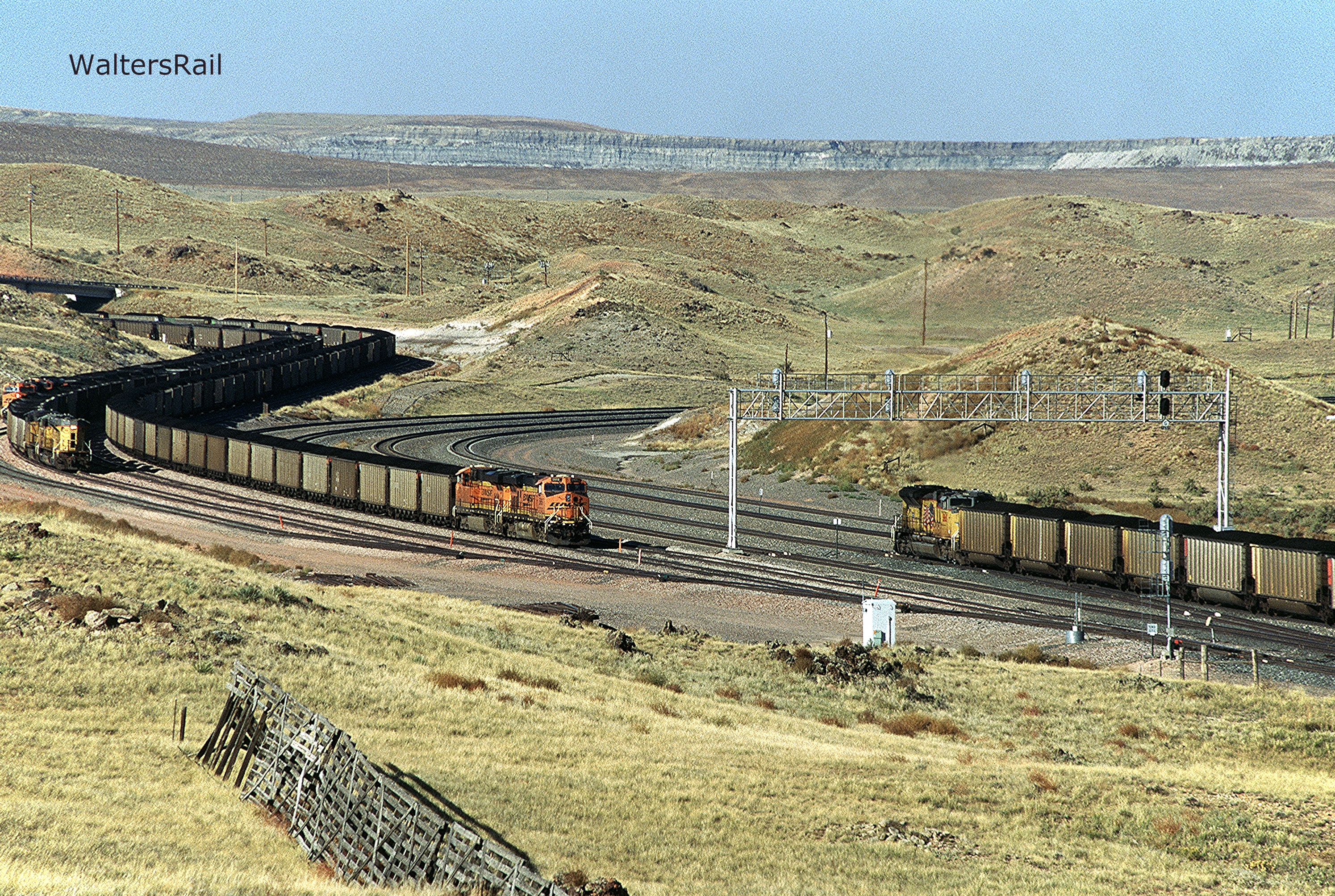
Traffic on the south end (occupied by both BNSF and UP) was another matter. I spent most of my time from the Lawver Road overpass south, which constitutes about the southern two-thirds of the line, triple and quadruple-tracked its entire length. Here traffic ranged from moderate to extremely heavy, anywhere from three to 12 trains per hour. One afternoon at Shawnee Junction yielded more than 30 trains (I lost count), which may or may not be consistent with traffic earlier this century but either way is significant in your author’s limited experience.
One afternoon I was standing beside a Forest Service road on a hill overlooking the tracks, which curved to the east in a valley far below. The sky was streaked with high cirrus clouds like strands of cotton. The National Weather Service would call the day “mostly sunny,” which translated into plain English means “lots of clouds.” On the northeastern horizon a huge puff of white smoke appeared suddenly, not a cloud, something more sinister. Several seconds passed, then came a low rumble, almost a growl, growing steadily louder, which continued for about the time it takes to read this sentence. Then, as the roar was dissipating, the ground began to shake, not violently but not gently, either. The ground shook the same way it does when a train is passing close by. It took another moment before I realized that one of the mines had just set off blasting charges.
In the following days, I saw several roadside signs warning of blasting, though I only experienced the one event. Even so, when I saw a sign, I did not further approach a mine. An overreaction? Probably, but I did not drive a thousand miles to photograph blast clouds.
I had been worried that I would see only a trickle of trains in the Powder River Basin, like water slowly leaking from an almost empty tub, and was relieved not to experience that fate. From talking to several people in and around the tracks, I gathered that traffic was down but not out. Everyone I spoke with was hopeful that the worst had passed. I hope that is so. I hope that our last railroad frontier is not eviscerated like the overburden blasted away to reveal the mighty seams of coal.
The following images start at Donkey Creek Junction and run south to Shawnee Junction.
Donkey Creek
This is the junction east of Gillette where the coal line ties into the old CB&Q tracks from Alliance, Nebraska, to Laurel, Montana. The junction itself sits beneath the overpass of Wyoming 51. To the southeast stand the Pine Bluffs of Nebraska and Crawford Hill. To the northwest lies the old Northern Pacific mainline, including the mountain passes at Bozeman and Mullan, plus the majestic canyon at Lombard.

 |
| BNSF's daily intermodal has entered the coal line at Donkey Creek. |
 |
| Northbound coal load approaching the junction. The tracks run along Dry Donkey Creek, surrounded by small bluffs dotted with mountain cedars and cottonwoods. |
 |
| Pushers on empty coal train headed south to the mines. |
 |
| Southbound empties. |
 |
| More southbound empties. |
Hoadley Road
Not far south of Donkey Creek Junction, the tracks wander off into their own world where no road follows. Bishop Road is the first crossing south of Donkey Creek, about ten miles south of the junction and accessed off Wyoming 50, about ten miles to the west. In times past, the dragline at Belle Ayr was close to the road and presented excellent photographic opportunities. Today (January 2023, almost 50 years since the mine opened), the dragline has moved far to the west; there is nothing much to photograph. The same is true at T-7 Road. The first decent shots now lie at Hoadley Road, several miles south. Hoadley Road is accessed by turning east of Wyoming 59 at Haight Road, then south on Hilight Road, then west on Hoadley, which takes you to an overpass across the tracks.

 |
| Southbound empties passing the spur to Coal Creek Mine. The tipple in the background belongs to the Cordero Rojo Mine. |
 |
| Pushers on same train attacking one of the grades between Donkey Creek and Shawnee Junction. |
 |
| Empties entering spur to Coal Creek Mine. |
Lawver Road
Lawver Road is accessed off Hilight Road to the west or Hoadley Road to the east and offers excellent photo opportunities. Traffic across the overpass is minimal. One can pause there for hours, if so inclined, and watch the parade of empties and loads on their way to and from the mines. Twin buttes rise to the west and provide impressive vistas to those willing to make the climb.

 |
| Pushers passing. |
 |
| Northbound load headed to Donkey Creek -- beneath the twin buttes. |
 |
| Southbound load passing beneath Lawver Road overpass. Coal Creek Mine tipple in background. |
 |
| Southbound load passing Coal Creek Mine. Image taken from one of the twin buttes pictured above. |
 |
| Another southbound. |
 |
| Southbound loads headed to Shawnee Junction. In the far background stands the dragline for the Coal Creek Mine. |
 |
| Northbound loads are almost lost in the expanse of the Powder River Basin. |
 |
| Southbound. |
 |
| BNSF's daily intermodal. Navigating stacks through coal trains must feel like swimming in sea weed. The Coal Creek dragline rises in the background. |
Hilight Road
Hilight Road runs south off Haight Road and passes within shouting distance of the Cordero Rojo Mine, where the dragline feels close enough to touch. In a few miles, the road and the coal line come together and run south side-by-side all the way to Edwards Road, passing Jacobs Ranch and Black Thunder.

 |
| Southbound on triple-track mainline. |
 |
| Meet at same location. |
 |
| Another meet further south. |
 |
| Pusher on southbound empties. |
Antelope Road
Antelope Road winds south from Mackey Road through the valley of Antelope Creek, passing some of the most rugged territory on the coal line, encompassing the School Creek, Antelope and North Antelope mines. The road is public, though driving on it feels as though you are deep in the bowels of private property.

 |
| Northbound approaching Antelope Road crossing. Behind the train are tailings from the North Antelope Mine. |
 |
| Northbound climbing grade, sandwiched between Antelope and North Antelope mines. |
 |
| Northbound empties. In the background, empties are on the spur to the North Antelope Mine. |
 |
| Southbound loads leaving Antelope Mine. |
 |
| Two loads preparing to leave Antelope Mine, while one empty is entering. On the main track, a UP load heads south. Just below the horizon stands a wall of the North Antelope Mine. |
Forest Service 942 Road (Logan Hill)
This road runs east from Wyoming 59 and crests a hill to present a panoramic view of the Antelope Mine and the tracks running toward it. Trains struggle in both directions up the grade, known locally as Logan Hill. One can also take good images from the overpass, as well as drive along the wide right-of-way beside the tracks. Here, perhaps more than any other location along the coal line, one senses the overwhelming vastness of this land.

 |
| A southbound load has left the Antelope Mine. |
 |
| This looks like a single huge train but it actually a BNSF southbound load passing UP northbound empties. |
 |
| More southbound coal headed to Shawnee Junction. The line here is quadruple-track. |
 |
| Pushers on northbound. |
 |
| BNSF chasing UP. |
 |
| A solitary pusher in the Wyoming wilderness. |
Bill
Bill, Wyoming, sits directly on Wyoming 59. Years ago, the "town" consisted of a small, wooden store and post office, combined in a single building, and nothing more. Now the store and post office are closed, replaced by a Union Pacific maintenance facility. A large motel sits across the road -- to house UP railroad crews going on or coming off shifts. Your author spent a week there, and the place seemed eerily quiet and empty, as though once filled with the sound of railroaders relaxing after 12 hard hours at work, but now sitting quietly, waiting for new occupants.

 |
| BNSF 6303 South prepares to duck under Wyoming 59 on the approach to Bill, Wyoming. |
 |
| Another southbound load approaches Bill. In the distance, above the middle of this train, a northbound empty rolls to the mines. |
 |
| BNSF meets UP, a common sight on the coal line. |
 |
| Bill, Wyoming. |
 |
| On a clear morning in late September (2022), southbound BNSF coal passes the Union Pacific facility at Bill, Wyoming. |
Jamie Street
Every map I have consulted calls this location "Jamie Street," which seems an odd appellation for a dirt road in rural Wyoming, but I shall not quibble with higher authorities. The road passes under the tracks, and the low elevation is perfect for evening shots after the sun has fallen.

 |
| Northbound pushers at dusk. |
 |
| Another northbound. |
 |
| Southbound. |
Private Road by Microwave Tower
This is the best description I can give for this road. The "private" portion actually starts on the west side of the tracks. One can roll in without trespassing and either drive or climb the fire-break that has been bulldozed on the west side of the tracks. The tops of the hills to the north and south yield impressive views.

 |
| Northbound empties have come down one hill and are climbing another. If you look closely, you will see the single headlights of two pushers going south. The microwave tower rises beside the highway. |
 |
| More southbound coal. As stated in the body of this article, traffic on the south end of the coal line was, at times, very busy during your author's visit. |
 |
| Pusher on same train. |
 |
| Southbound racing downgrade. |
 |
| As UP empties struggle upgrade, another BNSF coal load appears at the top of the hill. |
 |
| This was the fifth of six southbound loads to come through in less than an hour. |
 |
| The sixth. |
Highland Loop Road
Highland Loop Road runs south several hundred yards before crossing beneath the tracks, then turning north and northwest, climbing a moderate grade to reveal the grandeur of the Powder River Basin. This is a public thoroughfare and yields nice images of the country that early explorers found so daunting.

 |
| As this image indicates, there is also significant oil and gas production in the Powder River Basin. The Highland Loop Road underpass is shown in the left foreground. |
 |
| Southbound loads at dusk. The landmark microwave tower rises in the distance. |
 |
| Snow fences guard the tracks. |
 |
| Southbound coal -- down one grade and up another. |
 |
| Northbound across Highland Loop Road underpass. |
 |
| Northbound between oil production. |
 |
| "The same barren desert we have been in since leaving the Platte." |
At Shawnee Junction, the BNSF line coming north from Orin joins the UP line coming west from Lusk, and together they run north to the coal fields. East Antelope Road east out of Douglass will take you directly to this location, which offers multiple photographic opportunities from public right-of-way. At one time, landowners here guarded their property zealously. On your author's last visit, however, the land was deserted and open, as though a great crowd had once gathered but was now dispersed. If you want to see a lot of coal trains during the war on hydrocarbons, this is still your spot.

 |
| A BNSF coal load approaches Shawnee Junction from the northwest. |
 |
| A BNSF load has left the junction and is headed south to Wendover Canyon. In the background, UP empties are headed north to the mines. |
 |
| Northbound empties approach the Junction. |
 |
| Two loads running side-by-side have left the junction and are headed south. |
 |
| Modern railroading at its finest. |
 |
| Although mostly devoid of trees, this country (in late September) sports bright yellows and oranges in the creek and river bottoms -- in this case the West Fork of Shawnee Creek. |
 |
| UP tracks are directly to the left of the cab of BNSF 6119 South. Because the coal line was constructed in 1970's, it does not follow the path of least resistance, winding through creek and river bottoms where the only trees for a hundred miles grow. Instead, the tracks head out over open ground, with huge cuts and fills, creating marvelous photo opportunities. This is what all railroads would look like if constructed in the last half of the twentieth century. |
I am 72 years old (January 2023). When I was young, those inclined to worry fretted that the world was about to end in a nuclear holocaust. Those not inclined just lived their lives. In more recent years, the worriers now believe that the world will end in a climate holocaust unto death.
Unfortunately, the worriers gravitate to politics, where they make bad decisions. The war on hydrocarbons seems to me to be one of those really bad decisions that future generations will bemoan, like Prohibition and the Viet Nam War. Of course, I may be wrong. Time will tell.
To see my other posts, go to waltersrail.com.
To see my photographs on Flickr, go to https://www.flickr.com/photos/jpwalters/.
This is awesome. I had worked for UP during the summer of 1980 (many plans underway) and then for ATSF 1981-1984 and then for ALK Associates 1984-2000 so I thought I knew A LOT about modern railroad history. But now, on the verge of going to WY for the first time, your study of the Powder River Basin and WY is incredible. Thank you, Thank you.
ReplyDeleteOne little error (as I live in, and went to Princeton) is that at least around here, the English spelling of the Professor that COL Raynolds refers to is spelled "Guyot" https://geosciences.princeton.edu/about/history/1854-1900
I just finished reading part 1. I think I have now received my Doctorate in Power Basin Coal history. What a great read. Very inspirational, and offers a background of the earliest forms of energy that supplied this nation's growth for decades.
ReplyDelete