 |
| The El Paso and Southwestern Bridge Across Cienega Creek |
This article includes photographs of Union Pacific freights climbing the grade to the summit at Mescal, Arizona, from Benson on the east and the Cienega Creek Flyover on the west. The tracks diverge significantly on the western side, constructed many years apart by two entirely different railroads. Most everyone is familiar with the Southern Pacific, which built one line. Less well known, perhaps, is the El Paso and Southwestern, the company that constructed the second route.
A Short History of the El Paso and Southwestern
In southeastern Arizona, the city of Bisbee sits in a photogenic Western canyon, surrounded by rocky conical peaks, annually attracting thousands of visitors, most of whom take the tour through the long-closed Copper Queen Mine. Today almost no one is aware that Bisbee was “ground zero” for what was planned to be a second transcontinental mainline across far southern New Mexico and Arizona, paralleling and competing with Southern Pacific’s Sunset Route.
The Copper Queen transformed a New York importing firm into the Phelps Dodge Corporation, at one time the world’s leading copper producer. In 2007, the company was purchased by Freeport-McMoRan for $25.9 billion in cash and stock, creating the world’s largest publicly traded copper company, with over 25,000 employees.
The Copper Queen also financed the construction of the Arizona and South Eastern Rail Road, which eventually grew into the El Paso and Southwestern stretching into Mexico and three states with over 1200 miles of track.
In the 21st century, it is difficult to imagine the mining fever that overwhelmed the 19th. Thousands upon thousands of Easterners bet their families and fortunes on finding the vein of ore somewhere in the desolate West that would transport them to wealth beyond imagining. In 1877, a canyon in the Mule Mountains only a few miles north of the Mexican border was discovered by members of the 10th U.S. Cavalry, scouting for Apaches and looking for water. In a small stream they found ore that caused them to stake a claim in what became the Copper Queen Mine.
News of the discovery spread rapidly. Financiers from San Francisco moved in like vultures. The initial mine played out, but a second vein was discovered, the properties were combined and a new company formed to merge the two claims -- the Copper Queen Consolidated Mining Company, which produced copper rapidly and gleefully, like sausage. It soon became apparent that a railroad was needed to transport the company’s product to industrial centers. The Southern Pacific had reached the San Pedro River and had established Benson, Arizona, which could provide a natural connection to the mines in Bisbee.
Phelps Dodge initially experimented with an enormous steam traction engine to run on dirt roads to Benson, but the behemoth was ill-suited to the desert. It plowed through sand at the pace of a tired mule. After the lightest rain, its wheels would spin futilely and sink deeper and deeper into the muck.
In 1888, the Arizona and South Eastern Rail Road Company was incorporated to build north to Benson. The biggest construction obstacles involved the rocky terrain around Bisbee. Once out of the Sulphur Springs Valley (where Bisbee is located), the line ran through prime grazing land along the east bank of the San Pedro River. Local ranchers were not inclined to sell a portion of their property to a railroad, so the new company was often forced to file condemnation actions, which usually involved a sort of “frontier justice” – the lawyers, judge, railroad personnel and land owners spending a day examining the land in dispute, after which the judge would tell the parties that “it would be in your best interests to settle this case; otherwise, someone will get hurt.” Thereafter, the railroad would offer a reasonable amount for the condemned property, the rancher would accept, then everyone would go about his business.
Once the land had been acquired, initial construction proceeded apace, reaching completion in January 1889. The original line was 36.2 miles long, with no tunnels and almost 30 miles of tangent track across the mostly flat desert outside of the Sulphur Springs Valley to Fairbank, Arizona. 31 bridges were constructed in the 36 miles.
Construction of the extension to Benson began soon thereafter, when the general contractor began excavation and grading. The new line was over mostly level desert valley; work proceeded smoothly. In early August, southeastern Arizona was hit by a monsoonal downpour that deposited over a foot of water across the Sonoran Desert, halting construction. During the lull, a local sheriff got into a fight with and killed a Mexican worker, evoking anger and frustration in the construction camp, composed primarily of Mexicans, who nonetheless remained on the job and began work anew when the rains had subsided.
In late August another downpour inundated the construction zone. The San Pedro River was filled to overflowing and dislodged the newly constructed bridge at St. David downriver to Benson, where it collided with the Southern Pacific bridge. Heroic efforts saved the SP bridge, but the St. David structure was lost and required rebuilding.
The 19.1 mile extension from Fairbank to Benson extended the length of the Arizona and South Eastern to 55.3 miles and allowed Phelps Dodge to begin shipping the product of its mines to the Southern Pacific, which then carried the traffic on its mainline.
Still, traffic on the new railroad was light. Mixed trains were the rule, with one coach and one first-class car (the company’s entire passenger fleet), plus an average of nine freight cars, five of which were loaded. The average train carried 13 passengers; the average freight load was 100 tons, almost completely copper and coke.
As the Copper Queen increased production, the original smelter grew inadequate to process the ore. A larger smelter was needed, but the rugged terrain surrounding Bisbee precluded construction. Surveyors located an appropriate site about 30 miles west of town, but a railroad extension would be required -- a considerable distance from the connection with the Southern Pacific at Benson.
Phelps Dodge requested that the larger railroad construct a branch line from Lordsburg, New Mexico, to the new smelter, but the SP refused. Why should the railroad spend millions to construct track for a single customer when a connection already existed at Benson? So the Arizona and South Eastern Rail Road Company decided to build its own line east toward the new smelter and the SP.
Construction reached Douglas, Arizona (a short distance from the new smelter) in February 1901. A potential riot between local ranchers and the railroad graders was averted when a judge from Phoenix sent a posse to Silver Creek with instructions to restore order. Such was life in the West at the beginning of the 20th century. Come to think of it, not much has changed in the 21st.
Construction continued east of Douglass, even though Phelps Dodge had not decided exactly where it intended its new line to terminate. The road left the Sulphur Springs Valley and followed Silver Creek between College Peak and the Pedregosa Mountains.
In June of 1901, Phelps Dodge announced that the railroad would connect with the SP at Deming, New Mexico. Construction commenced from Deming soon thereafter, with crews now building both southwest from Deming and northeast from Douglas. Then the name of the railroad was changed to the El Paso and Southwestern Railroad Company, indicating the railroad’s ultimate destination.
In New Mexico, grading and track work proceeded briskly over ground often as flat as a lake bed. On February 13, 1902, the first train ran on the 155 mile railroad, linking the new Phelps Dodge smelter with the Southern Pacific mainline at Deming. Four months later, tracks from Hermanas, New Mexico, to El Paso, Texas, were completed. The railroad began advertising itself as the “Sunshine Line.”
At about the same time, the last spike was driven on the El Paso and North Eastern in Santa Rosa, New Mexico, completing the dream of Charles B. Eddy to reach the coal mines and timber of eastern New Mexico and form a new transcontinental link with the Chicago, Rock Island and Pacific. Eddy sold his railroad to the El Paso and Southwestern in 1905, the same year that Phelps Dodge purchased the coal mines. With this acquisition, about 75 percent of the EP&SW’s mileage was located outside Arizona – mostly in New Mexico.
Nevertheless, this was a railroad that both began and ended in the middle of the desert. At Santa Rosa, the EP&SW connected with the Rock Island, with through service to Kansas City, Chicago and Memphis. At Deming, the railroad connected to the Santa Fe, with tracks heading north to Albuquerque and ultimately Kansas City. And at Benson, connection was made with the Southern Pacific and points west to Tucson and Los Angeles. But the EP&SW did not itself serve any significant population base other than El Paso. Absent the Phelps Dodge mines, the railroad was without traffic.
The EP&SW therefore decided to build west to Tucson. The locating engineer, R.H. Jones, chose a route that avoided Cienega Creek, where flooding had caused repeated problems for the SP. He also decided to avoid the 1.4% ruling grade followed by the SP from Benson to the Mescal summit, adopting a route beginning near Fairbank and winding leisurely over 24 miles, with a ruling grade of 0.3 per cent as the tracks navigated around the Whetstone Mountains.
The Tucson route was intended to be part of a new transcontinental mainline, so engineering and construction standards were state-of-the-art for the early 20th century. To avoid Cienega Canyon, the new line crossed the Southern Pacific near Mescal on a 200 foot steel bridge, then ran parallel to the SP for a few miles, then along the edge of the mountains 14 more miles until crossing the SP again on a 536 foot steel bridge that also spanned Cienega Creek. Construction to Tucson was completed October 31, 1912.
 |
| This was the EP&SW's crossing of the SP near Mescal. After the companies' merger, the line from Fairbank was abandoned, while the line downgrade to Tucson was maintained. The bridge and embankment were removed. This image comes from Railroads of Arizona by David F. Myrick, long out of print. Old copies are available, however, on Amazon. Also, a digital version can be found at https://archive.org/details/railroadsofarizo01myri/page/n7/mode/2up. This book gives a much more detailed account of the El Paso and Southwestern and was relied upon heavily by this author. |
The El Paso and Southwestern now stretched from Santa Rosa to Tucson and thought of itself as one of three transcontinental routes from Chicago to Southern California, along with Santa Fe and Southern Pacific. To secure the Chicago terminus, the EP&SW purchased a significant interest in the Rock Island. Then it negotiated an agreement with the SP, opening the Tucson gateway to freight and passenger traffic. In November 1913, the Golden State Limited (Rock Island’s passenger train from Chicago to Los Angeles) was routed west out of El Paso on the EP&SW to Tucson, where it then transferred back to the SP for the run to the Pacific.
 |
| Map of the El Paso and Southwestern from the Official Guide of the Railways. |
But the good times did not last. Many forget, and many may not even know, that during America's participation in the First World War, from December 28, 1917, through March 1920, the federal government operated the nation’s railroads. Not surprisingly, the industry suffered. The government may be good at some things, but running railroads is not one of them.
Copper producers, on the other hand, prospered during the war. Demand was great and prices high. The EP&SW’s struggles were offset by the prosperity of Phelps Dodge.
Everything changed at the end of the Great War. Rail traffic dropped precipitously. The El Paso and Southwestern’s was down 60 percent, because its primary revenue source, copper mines, either curtailed or stopped production altogether -- because the end of the war knee-capped the demand for copper. Both the railroad and Phelps Dodge soon realized that they could not survive the new status quo.
In January 1921, officials of the EP&SW met with the Southern Pacific to discuss a potential partnership. The smaller road proposed double-tracking the SP line from Tucson to Yuma and Los Angeles, one track to be owned by each railroad. SP called the proposal “ridiculous.”
At the same time, Congress removed most railroad regulation from the states, transferring control to the Interstate Commerce Commission, which was required to prepare a nationwide plan assigning the many independent American railroads into simplified regional systems. The ICC published a tentative schedule of consolidation in 1921, combing the Rock Island, Southern Pacific, El Paso and Southwestern, and several short lines into “System No. 17.”
Although the ICC never enforced consolidation, the Southern Pacific thereafter expressed interest in the EP&SW. Both roads were certain, however, that the Commission would not approve a merger unless the combined companies agreed to construct a mainline through Phoenix.
In 1924, the SP agreed to acquire the EP&SW for 280,000 shares of Southern Pacific stock (worth 89 dollars per share), plus $29,400,000 of SP bonds. The acquiring company also agreed to assume the responsibility for $9,100,000 of EP&SW bonds held by the public. Finally, Southern Pacific committed to building a line through Phoenix, connecting with the existing Sunset Route at Red Rock, Arizona, on the east and Indio, California, on the west.
On July 1, the railroads filed a joint application with the ICC for approval of the merger. The Commission, not afflicted in those days with regulatory arthritis, held brief hearings and approved the request on October 1, with the condition that construction of the line to Phoenix begin before January 1, 1925, and be completed in two years.
When the Great Depression hit, traffic from copper mines evaporated. At the Copper Queen in Bisbee, mining ceased October 1931. And when a natural gas pipeline was constructed into Bisbee and Douglas in June 1931, Southern Pacific lost the fuel oil business. Thereafter followed the abandonment of most of the former EP&SW branch lines: Hermanas-Deming; Hachita-Oil Siding; and Douglass-Courtland.
The former EP&SW’s mainline to El Paso saw fewer and fewer trains, especially after the installation of centralized traffic control on the original SP mainline. And as Southern Pacific ruthlessly cut passenger trains, like a butcher slicing sirloin, the need for a second, parallel mainline disappeared. Thus, almost predictably, the SP filed with the ICC to abandon the EP&SW mainline to El Paso, claiming that elimination would save the company half a million dollars per year.
The ICC ultimately granted the request, but the day before the scheduled abandonment, a federal court issued a temporary injunction forbidding the SP from removing the tracks, though operations had already ceased. This litigation drug on for a while, as litigation always does, while the lawyers earned their fees. Eventually, however, the U.S. District Court for Arizona affirmed the ICC’s decision, and the 208.9 miles of rails to El Paso were removed.
The EP&SW mainline to Tucson was another matter – a route constructed many years after the SP line and to the highest standards of the time, avoiding both the grades and the frequent flooding of Cienega Creek. Because it would have added about 50 miles to the journey, Southern Pacific chose not to keep the EP&SW’s route from Fairbank to Mescal, though the grade was much less severe. Also abandoned was the steel girder bridge across the SP at Mescal. From that location at the summit, however, the SP maintained the EP&SW line almost all the way to Tucson as a second main which, because of its better engineering standards, thereafter became the route of choice for SP dispatchers.
Today, the 18 mile eastward climb from Cienega Creek to Mescal and the 10 mile westward climb from Benson, constitute one of the three summits that trains must surmount between Tucson and the New Mexico border – the others being Dragoon and Steins. On the Tucson side of the grade, eastbounds favor the original SP line through the creek bottom, while westbounds race down the EP&SW route along the edge of the mountains. But when the tracks are clear, dispatchers will often route eastbounds over the newer line, and if you close your eyes, you can almost believe that the El Paso and Southwestern still blazes proudly through the desert.
The Maps
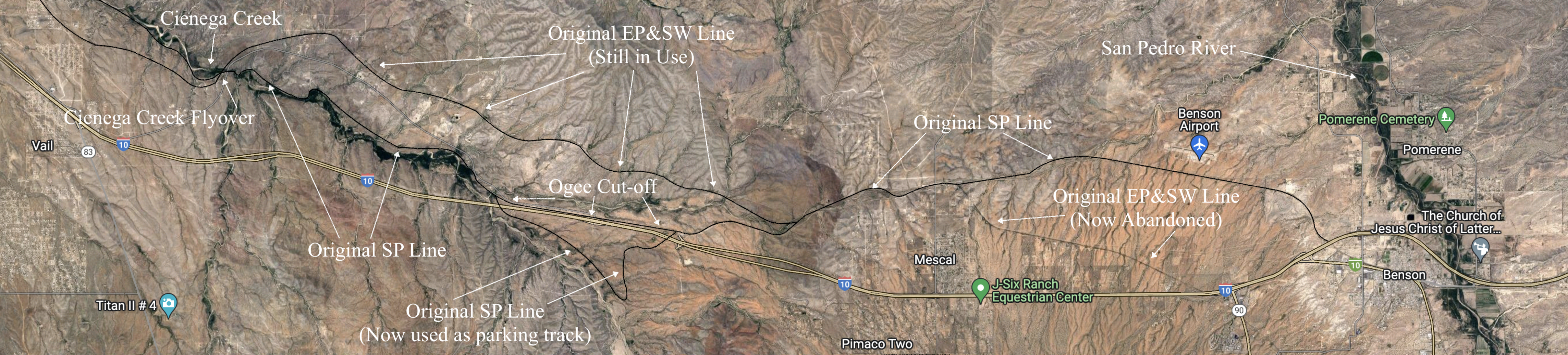

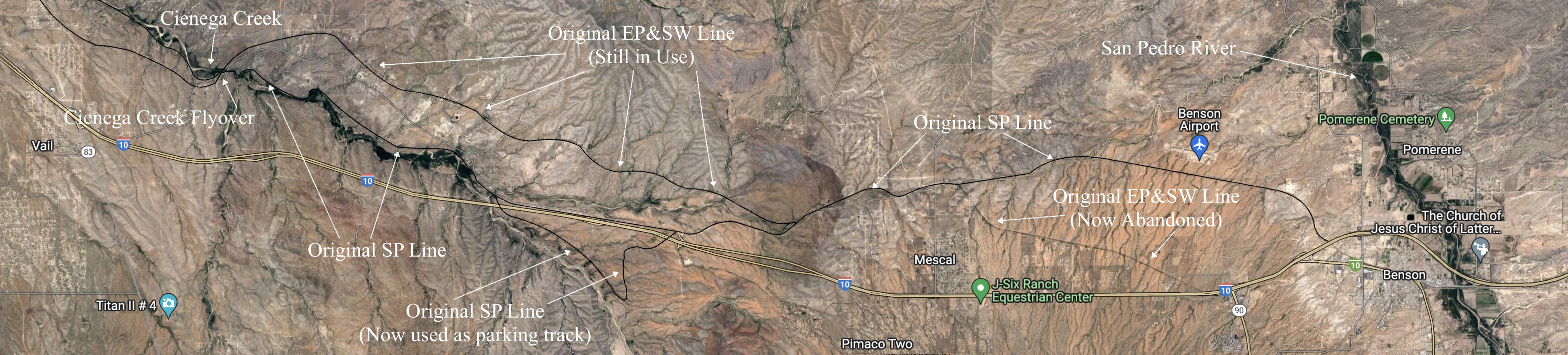
The above maps show the area photographed. The San Pedro River, on the right in the first map, flows north into the Gila River east of Phoenix. Cienega Creek originates in the Canelo Hills and flows northwest about 50 miles to near Tucson, where it is called Pantano Wash, then continues through Tucson, eventually connecting with the Rillito River.
The original Southern Pacific line to California is shown, along with a section in the bottom center of the first map (including an impressive horseshoe curve) that was bypassed several years ago by a line relocation (the "Ogee Cut-off") and is now used as a parking track.
West of Mescal and north of the original SP line run the tracks constructed by the El Paso and Southwestern as a competing transcontinental route and still used today by Union Pacific. In the lower right of the first map is the portion of the EP&SW mainline abandoned when the two roads merged.
In the upper left is the Cienega Creek Flyover, a huge steel girder bridge constructed by the EP&SW to cross the SP tracks.
The Photographs
The images that follow were all taken of Union Pacific power in the 21st century, climbing both the eastbound and westbound grades to Mescal. We start on the grade west of Benson, climb to the summit, then follow the tracks to the steel girder bridge across the original SP line at Cienega Creek, one of the more spectacular photographic locations for Western rail photography.
 |
| Westbound autos are climbing the grade out of the San Pedro Valley on their way from Benson to the summit as Mescal. This is the original route constructed by the Southern Pacific. The original El Paso and Southwestern line to Mescal crossed the SP line several miles to the west. |
 |
| Eastbound rolling downgrade -- about four miles from Mescal. |
 |
| Westbound stacks led by the Kansas City Southern. |
 |
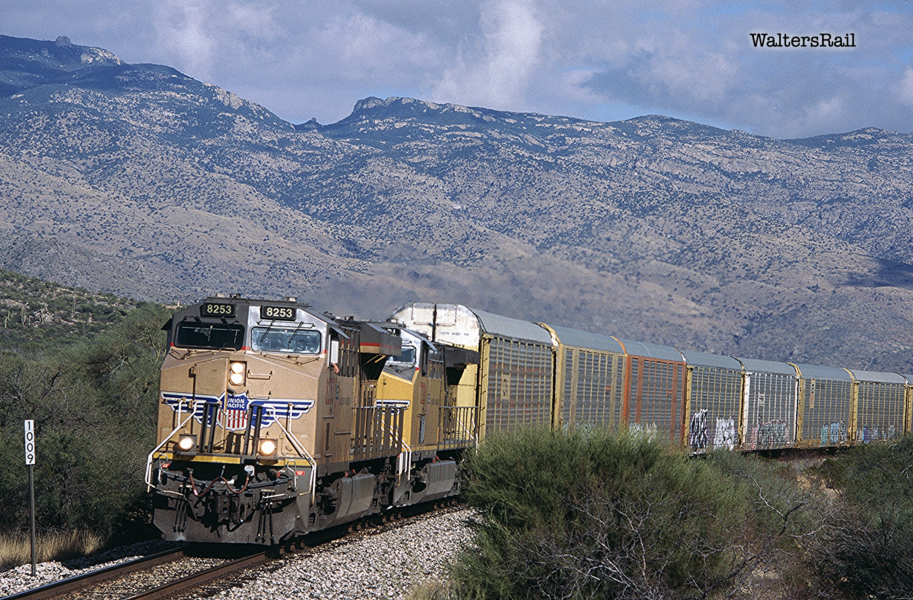
| Westbound at the top of the Mescal grade. |
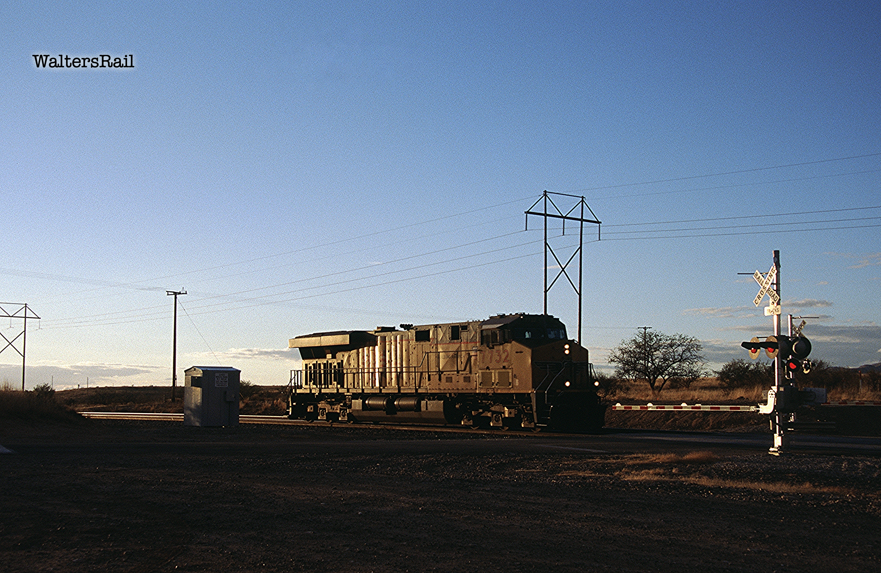 |
| Eastbound light engine at Mescal. |
 |
| Westbound stacks have diverged from the original Southern Pacific mainline and are rolling downgrade on the old El Paso and Southwestern main. |
 |
| Westbound on the EP&SW. |
 |
| DPUs on same train. |
 |
| Eastbound grinding upgrade on original Southern Pacific main. |
 |
| Eastbound stacks on the Ogee Cut-off, a realignment of the original SP main. The original line (leading to a horseshoe curve now used as a parking track) is in the foreground. |
 |
| Ogee Cut-off Junction. |
 |
| An eastbound mixed freight is climbing the grade on the realignment of the original SP main. |
 |
| The UP dispatcher has routed this high-priority eastbound over the EP&SW. |
 |
| A small window of sunlight illuminates these westbound stacks on the EP&SW main. |
 |
| Westbound autos on the EP&SW main are approaching the Cienega Creek Flyover. |
 |
| The Cienega Creek Flyover. Below the bridge are the creek and the original Southern Pacific mainline. |
 |
| Same. |
 |
| Same -- before photographer is caught in the downpour. |
 |
| The Cienega Creek Flyover in the rain. |
 |
| The Flyover at dusk. |
 |
| Easbound UP grainer along Cienega Creek, approaching the Flyover. |
To see my other posts, go to waltersrail.com.
To see my photographs on Flickr, go to https://www.flickr.com/photos/jpwalters/.
No comments:
Post a Comment